
MSDA // Photographs / M03
Latin America
1989-1999
4 galleries of digitized film slides covering urban landscapes in Central and South America
OVERVIEW
These digitized slide photograph galleries illustrate housing conditions, city layout and infrastructure, and resident communities in Colombia, Bolivia, Chile, Paraguay, Peru, Ecuador, Mexico, and Venezuela, from 1989 to 1999.
The following galleries represent a selection from the original slide curation established by Mona Serageldin, corresponding to a slide box titled “Latin America.”
Related Materials:
Related image collections:
- MSDA Photograph Collection M26, Gallery 3: Latin America (1987-2001)
- MSDA Photograph Collection M28: Brazil (1996-2001)
- I2UD Photograph Collection, Gallery 4: Chile (1992-1993)
- I2UD Photograph Collection, Gallery 16: Venezuela (1989)
- I2UD Digital Library Study Guides, Informal Settlements Album
Galleries
Gallery M03-1: Colombia, Bolivia, Chile, Peru, Paraguay, and Ecuador (1990s)
Gallery M03-2: Ecuador (1995, 1999)
Gallery M03-3: Mexico City, Mexico (1988-1999)
Gallery M03-4: Venezuela (1989-1993)
Previous Page: Medieval Cairo (M02)
Next Page: Historic Districts (M05)

GALLERY M03-1: Colombia, Bolivia, Chile, Peru, Paraguay, and Ecuador (1990s)
67 images
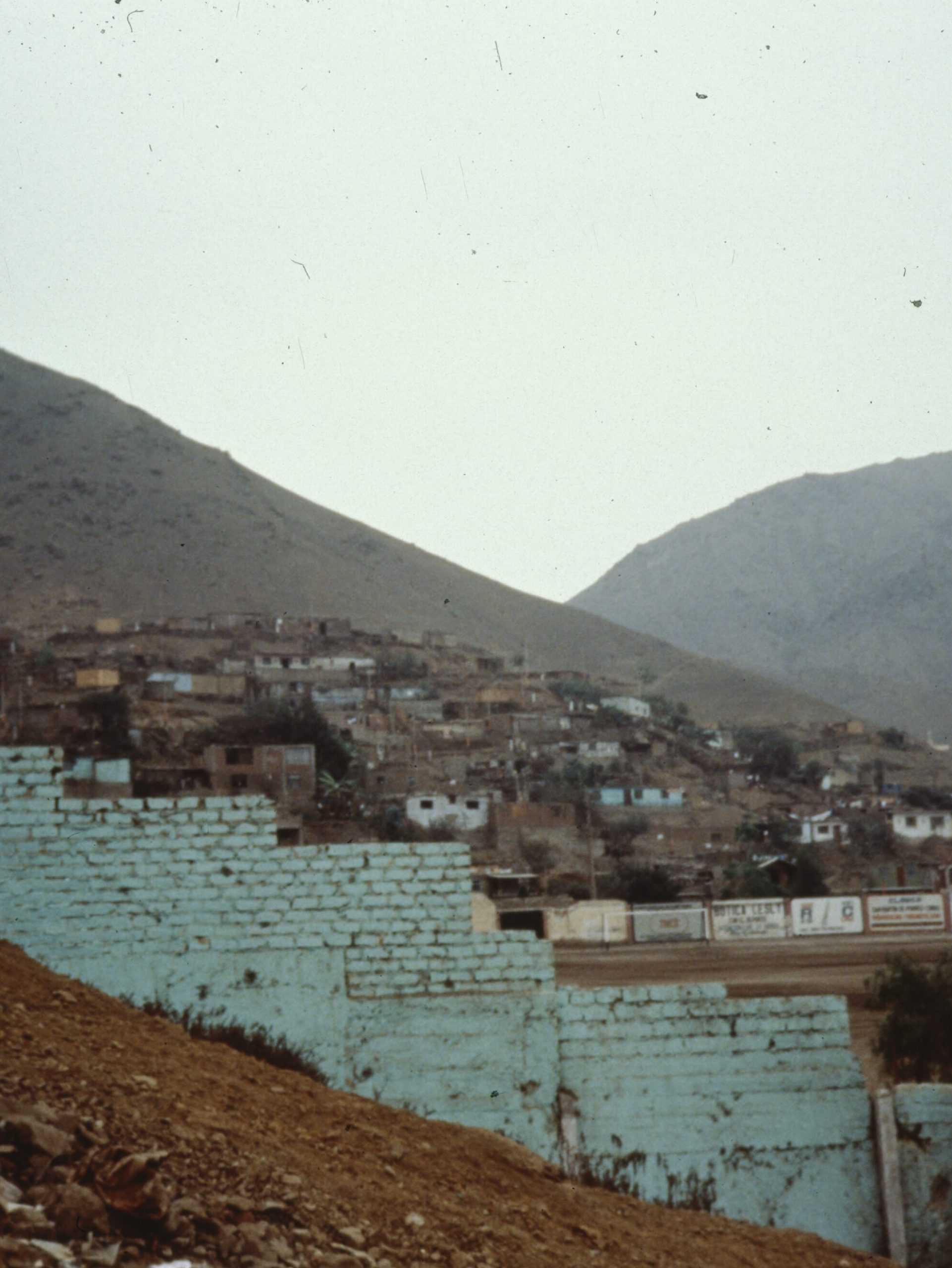
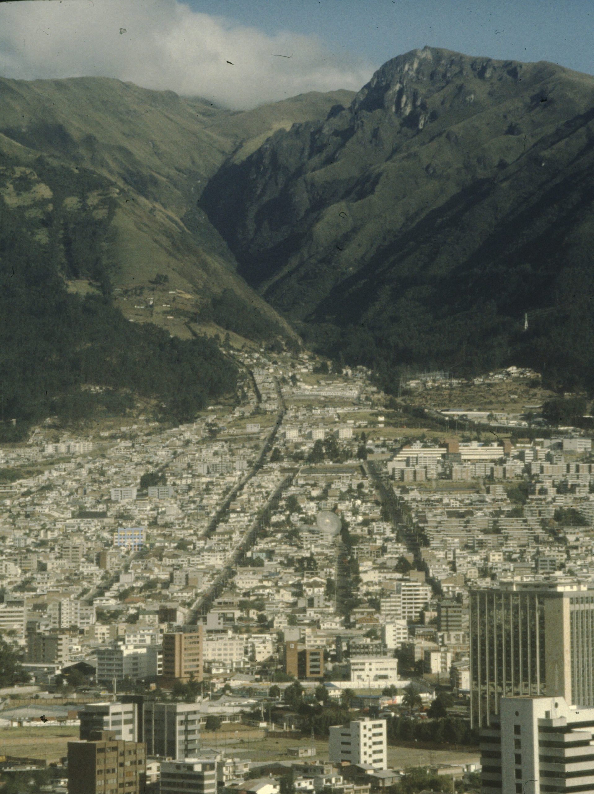
Digitized slide photographs of communities across Bogota, Columbia; La Paz, Potosi, Bolivia; Santiago, Chile; Lima, Peru; Asuncion, Paraguay and the outskirts of Quito and Cayumbe, Ecuador, from the 1990s.
This gallery surveys urban growth in Latin America, featuring a range of urban scenes and rural communities, comparing housing, transportation, infrastructure, local industry, yards and neighborhoods. Images include candid portraits of residents inhabiting a range of community settings, including street scenes, persons working, food and freelance vendors, women, and families of young children.
La Paz, Potosi, Bolivia: Slides of photographs of street markets, craftsmen and residents in La Paz, Potosi, Bolivia, including an 1993 Estimation for micro merchant “free lancers” and female vendors.
Santiago, Chile: Slides of photographs of housing, buildings and community in Santiago, Chile.
Lima, Peru: Slides of photographs of housing, streets, parks, municipal buildings, landscapes and residents in Lima, Peru, including portraits of local project partners and residents.
Quito, Ecuador: Slides of photographs and graphic maps of transportation, skylines with houses, poor areas in South Quito (Apahuasi), children in South Barriosta Ana., residential areas la Primavera y San Vicente, the Gonzales Suarez quarter.
Cayumbe, Ecuador: Slides of photographs of houses, and community in Cayumbe, and outskirts of Quito, Ecuador, including scenery, hillsides, brick making, housing, house construction project, and street scenes.
Asuncion, Paraguay: Slides of photographs of scenes in Asuncion, Paraguay, showing houses, children, yards and neighborhoods, boats and waterfront, sunrise with fishermen.
Gallery M03-1. MSDA: Mona Serageldin Digital Archive. Institute for International Urban Development. I2UD Digital Library. Digitized June 2021.


GALLERY M03-2: Ecuador (1995 and 1999)
171 images
Digitized slides depicting an urban development survey of Quito Ecuador, from April 1999, and of Cayumbe and Santiago de Guayaquil, Ecuador, from January 1995. Photographs include views of South Quito (Apahuasi), South Barriosta Ana, the residential areas of la Primavera y San Vicente, Gonzales Suarez quarter, and an indigenous agricultural community in Cayumbe.
A selection of graphic maps depict urban growth trends in Ecuador, from 1990s, 1995-1999. Photographs show overviews of expanded urban municipalities including Esmeraldas, Carachi, Imbabura, Sucumboís, Napo, Pichincha, Manabí, Los Rios, Bolivar, Chimborazo, Cañar, Guayas, Cotopaxi, Tunguradua, Pastaza, Morona Santiago, Azuay, El Oro, Loja and Zamora Chinchipe. Graphics show metropolitan space configurations, expansion areas, ecological protection zones around Quito, potable water supply in Ayora-Cayambe Parish and cartography of regional expansion across Ecuador.
Images from Cayumbe depict a community housing construction project underway, and existing housing, with resident indigenous agricultural community, including portraits of men, women and children, from January 1999.
Images from Santiago de Guayaquil include views of housing and community infrastructure, showing waterfront houses on stilts, local commerce, families with young children, and young adults at the Guayaquil Plan Internacional vocational center.
Additional subjects include houses, porches, yards, sheds, trash heaps, transportation, skylines, hillsides showing urban expansion, exteriors and interiors of houses, portraits of residents and children.
See also: I2UD Digital Library Study Guides, Informal Settlements Album
Gallery M03-2. MSDA: Mona Serageldin Digital Archive. Institute for International Urban Development. I2UD Digital Library. Digitized June 2021.


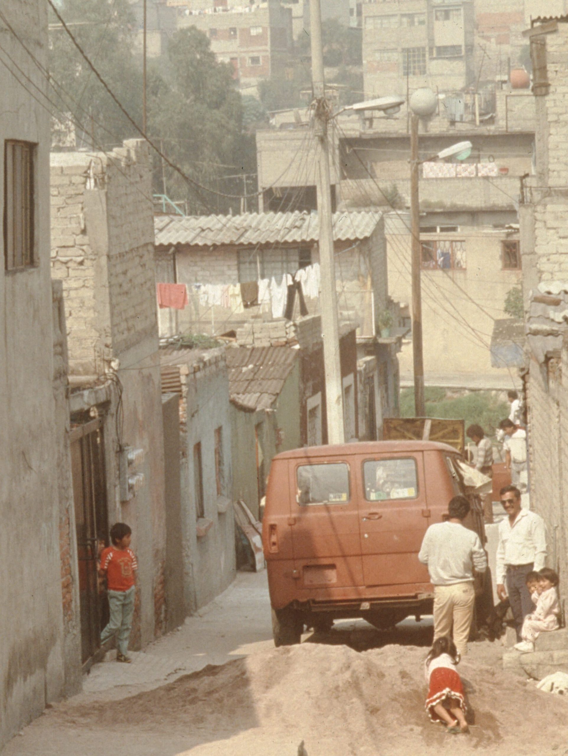
GALLERY M03-3: Mexico City, Mexico (1988-1999)
282 images
Municipalities pictured:
Mexico City, Mexico (1990-1991)
Slides of photographs of houses, residents and street scenes in Mexico City, Mexico.
Gallery M03-3. MSDA: Mona Serageldin Digital Archive. Institute for International Urban Development. I2UD Digital Library. Digitized June 2021.


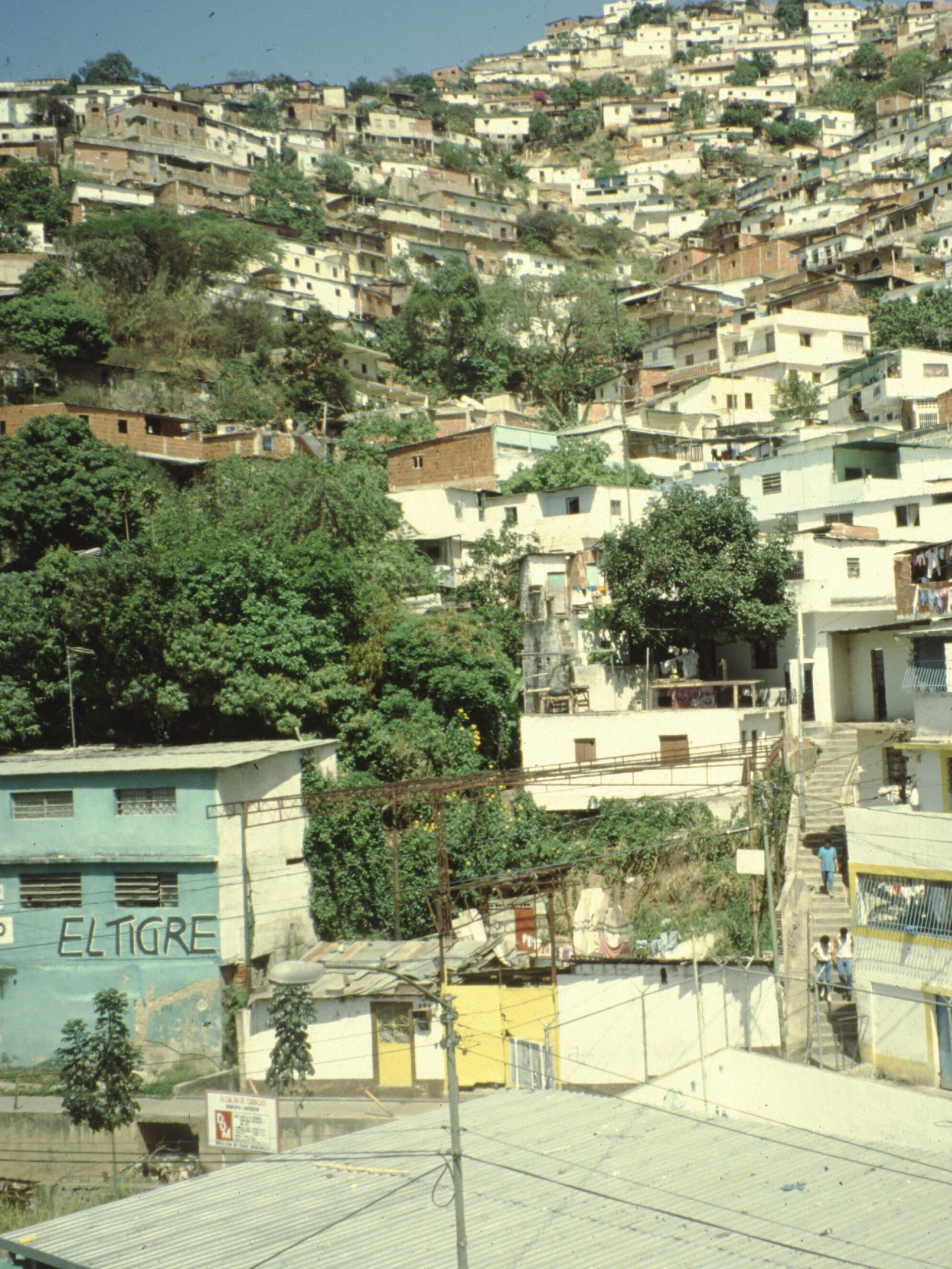
GALLERY M03-4: Venezuela (1989-1993)
192 images
Digitized slides showing urban housing in Venezuela, 1989-1993. Images show housing in Carapita, Caracas, Antimano, Santa Cruz Del Este, Amelia (Le Vega) Lucia, Florencia (Aragrea Maracay), La Candelaria (old class section), El Hormiguero, El Milagro and many views of the Caracas urban region, including Las Mercedes. Includes detailed views of housing exterior/interior of homes or trailers, with residents, with installed with home-based micro-enterprises. Includes with slides on Latin America Densification Land in Venezuela, with overviews, streetscapes and maps of Venezuela.
See also: I2UD Digital Library Study Guides, Informal Settlements Album
Gallery M03-4. MSDA: Mona Serageldin Digital Archive. Institute for International Urban Development. I2UD Digital Library. Digitized June 2021.


Previous Page: Medieval Cairo (M02)
NExt Page: Historic Districts (M05)