“Financing Infrastructure Upgrading Programs,” Two Urban Development Research Papers, Dr. Mona Serageldin, 1989-1991

Abstract

From 1989 to 1991, Dr. Mona Serageldin authored two related papers on financing urban development for the Unit for Housing and Urbanization at Harvard University: “Financing Upgrading Programs (November 1989) and “Financing Infrastructure Upgrading Programs (March 1991).

The papers assessed the exchange components of local and foreign currency, as cost factors in urban development upgrading projects. Dr. Serageldin focused on three main needs to establish effectively financed upgrading programs: 1) Construction of new infrastructure networks, 2) Building and improvement of community facilities like schools and health centers, and 3) Creation of homeowner credit mechanisms to improve residential properties. Municipalities in Jordan, Tunisia, and Hafsia provided example case studies.


[Excerpt: “Financing Upgrading Programs, November 1989”]

“…Upgrading is widely held to be the most effective mechanism to expand the supply of housing for limited income groups and improve living conditions for the urban poor. By providing the support infrastructure, it opens up opportunities for new economic activity.”

“Despite highly publicized haranguing by U.N. Habitat, housing is no longer viewed as a priority for public expenditure by international funding organizations and bilateral aid agencies. The debt situation in developing countries implies a widening gap between urgent needs and potential resources. Demographic pressure and the economic crisis have concentrated efforts on economic development and employment generation rather than social infrastructure.”

See related I2UD projects below

Project Year:1989-1991
Project Type:Research Paper
Geographic Regions:Global / None Specified
Reports:

Financing Upgrading Programs: (Mona Serageldin, November 1989)


Financing Infrastructure Upgrading Programs: (Mona Serageldin, March 1991)

Authors:Mona Serageldin
Sponsors:Unit for Housing and Urbanization at the Harvard University Graduate School of Design (1989); USAID Office of Housing and Urban Projects (1991);
Categories:Reconciliation and Development
  
ID:1989_11_001

Related I2UD Projects

Tags

“Environmental Health Factors in Housing,” Design Study for the Rapid Urbanization of Low-Income Settlements in Urban-Fringe Districts, 1989

Abstract

“Environmental Health Factors in Housing” was a study from 1989 by the Unit for Housing and Urbanization — addressing the link between rapid urbanization and rapid densification of low-income housing settlements in economically struggling cities — called the “Third World” in 1980s-era economic terminology.

The report addressed the environmental hazards, poverty, disease and slum housing conditions emerging in areas around housing developments built recently but lacking adequate infrastructure for socio-economic longevity and community health. The Unit presented their aim to form a model for affordable, practical design criteria that paid attention to both economic and social factors for urban-fringe districts.

Documents include working reports from April, July and August 1989, a Study Summary, and a Research Strategy and Methodological Guidelines by Rafique H. Keshavjee (Ph.D. Orville Solon, Ph.D.) from December 1989.


[Excerpt: Study Summary, I. Overview, July 1989, p. 2]

“Most urban settlements in lower-income countries, whether they are new settlements built by the government, established informal communities or new squatter areas, are subject to tremendous pressures of population growth and economic and physical change. The greater the pressure for development, the more rapid the transformations brought about by this maturation process. This continuous growth and change can rapidly transform their original physical forms beyond recognition and alter the community’s social and economic functions. The process is further intensified when governments introduce improvements such as water, sewerage, basic services and housing. For example, carefully planned housing projects designed according to standards which assume a segregation of commercial and residential activities will find that, overtime, these activities will occur simultaneously in the same area.

The need of low-income families to generate additional income and living space results in the construction of new rooms and apartments which were often not anticipated in the original design of the site or its infrastructure. In such cities as Karachi, Dhakka and Cairo, where housing shortages are high, additions to structures can reach over six stories in less than five years, raising densities from under 400 to over 1,000 persons per hectare. The most dynamic aspect of transformation within a community affects housing, small scale commercial establishments and the disappearance or overuse of communal open
spaces.”

…..

[Excerpt: Study Summary, III. STUDY DESIGN, July 1989, p. 7]

“The purpose of the Study is to develop practical, affordable design criteria which are responsive to the social and economic dynamics of low-income settlements. It will focus on aspects of housing and community design which have received little attention in the past. Most notably, the long-term impact of rapid growth in low-income urban settlements and the effect of the resulting transformation of housing and environmental conditions on the health of the residents. The definition of this linkage and the development of appropriate environmental design criteria, will allow decision makers to choose physical improvements that will maintain their positive impacts as a community matures.

Project Year:1989
Project Type:Environmental Climate Research Paper
Geographic Regions:Global / None Specified
Reports:
Environmental Health Factors in Housing: (April 1989)


Environmental Health Factors in Housing: (August 1989)


Environmental Health Factors in Housing: (July 1989)


Environmental Health Factors in Housing: (Summary, July 1989)


Environmental Health Factors in Housing: Research Strategy and Methodological Guidelines (December 1989)

Authors:Rafique H. Keshavjee, Ph.D.; Mona Serageldin; François Vigier;
Sponsors:World Health Organization; Ford Foundation;
Categories:Climate Change and Resilience Building
  
ID:1989_07_001

Tags

“Geographic Information Systems: The Spatial Dimension of Urban Information Management,” Early GIS Research Paper by Dr. François Vigier, Jonathan Corson-Rikert, and Joy Hecht, July 1989

Abstract

The paper “Geographic Information Systems: The Spatial Dimension of Urban Information Management” was written in July 1989 by François Vigier, Jonathan Corson-Rikert, and Joy Hecht under the Unit for Housing and Urbanization at the Harvard University Graduate School of Design.

The report reviews the emerging field of Geographic Information Systems (GIS) in 1989, and summarizes its administrative and technical applications. It discusses information systems in urban management, the development of computer mapping and geographic information systems, the use of GIS in urban management, the management of streets and utilities, and potential system expansions for the technology.

A history of using GIS systems in urban development is related to I2UD’s latest focus on Artificial Intelligence (AI) geographic imaging systems. Early concepts from 1989 can be compared to—or demonstrate the origins of—modern GIS mapping technologies like Artificial Intelligence (AI).

Excerpt


[Excerpt: “Geographic Information Systems: The Spatial Dimension of Urban Information Management,” July 1989, p. 2]

“The evolution of computer technology over the past ten years offers new opportunities in this field to Third World cities. Software that integrates management systems with geographic data offers municipal officials new ways to approach technical problems, by addressing directly the spatial dimensions of the issues.

Conventional tools allow the development of quantitative estimates of future trends; only the ability to visualize their probable impacts in space allows a realistic conceptualization of growth or of changes in the quality of urban life. Planning strategies that are responsive to the pressures of rapid growth, effective in the management of the physical plant, and sensitive to the need to allocate scarce public resources depend on the merging of analytical techniques and spatial decisions.”

[Excerpt cont’, p. 8]

“Geographic information systems, linking maps and data base management systems make the storage and management of a wide range of spatial information possible. No longer an isolated component used to display results or store geographic data, computer mapping has become an affordable integral part of urban management.”

See related I2UD projects below

Project Year:1989
Project Type:Research Paper
Geographic Regions:Global / None Specified
Reports:
Authors:François Vigier; Jonathan Corson-Rikert; Joy Hecht;
Sponsors:Unit for Housing and Urbanization
Categories:Reconciliation and Development;
  
ID:1989_07_002

Related I2UD projects

Tags

Design Studio 1989: “Rabat’s Urban Fringe,” Urbanization Analysis of Rabat, Morocco – Seminar Curriculum

Abstract

The Design Studio from 1989, “Rabat’s Urban Fringe” presented the urban evolution of Rabat, Morocco from 1987 to the early 1990s. The seminar covered Rabat’s urban development experience as a case study for Seminar attendees. The Seminar was hosted by the Harvard Aga Khan Program for Islamic Architecture at Harvard University, and the Massachusetts Institute of Technology. Professors Dr. Francois Vigier and Dr. Mona Serageldin led the sessions, research, and discussions.

Seminar materials focused on analyzing methods to accelerate the release of land for urban development in Rabat, and to discourage imbalanced city growth patterns. The Studio covered the application of standards that balance climate requirements, socio-cultural needs, and affordability, the creation of cost-efficient designs to support the economic life of projects, and the use of politically-feasible mechanisms to improve cost recovery and affordability. This topic was repeated for Urban Design Studio curricula from 1989 to 1993.

Documents include: A Seminar Syllabus and overview report; A Full report, “Rabat’s Urban Fringe,” with text by Dr. Mona Serageldin, supported by Seminar’s research team, and a final student report on urban planning in Rabat.


[Excerpt: Syllabus, Overview, Spring 1989, Mr. Vigier, Ms. Serageldin, pp. 1-2.]

Urban Housing in Rabat, Morocco,” An Overview:

“Urban areas of Third World countries are growing rapidly as a result of a high rate of natural increase of the population and of migration from rural areas. In older areas, usually highly accessible to a broad range of job opportunities, continued population pressures is causing a densification of the housing stock which is deteriorating rapidly from lack of maintenance and subdivision into smaller units. Their infrastructure systems are utilized well beyond their design capacity, creating an increasingly unsanitary environment and threatening the structural soundness of buildings. More recently, governments have had to cope with a dynamic private sector whose activities have proved difficult to control.”

“At present [ca. 1989], the urban fringe is developing rapidly as squatter and informal settlements, ranging in quality from little more than shacks to sound housing for moderate income households striving to improve their standard of living, are built illegally. Currently accounting for sixty to eighty percent of housing starts, these fringe developments present an unprecedented challenge to planners and public officials concerned with preventing urban sprawl and maintaining control over the dynamics of growth in order to provide efficiently the necessary infrastructure and services.”

Planning and Design Issues. High rates of urban growth necessitate forceful public interventions to direct the development of the urban fringe and improve the functional efficiency of older districts. Located in both older areas and on the urban fringe, large-scale projects are being undertaken to upgrade the infrastructure, extend the capacity of transportation systems, provide public amenities, and build mixed-use developments.”

“Yet, the prevalence of poverty has overtaxed the ability of governments to provide adequate public services or enforce even minimum sanitary standards of housing for the majority of urban households. Government housing policies have sought to reconcile three potentially conflicting objectives:

— “A commitment to improve the standard of life of a population largely unable to afford safe and sanitary housing on the open market.”

— “The desire to utilize planning and design standards reflecting international norms as the means to provide an acceptable level of amenities in both older areas and the developing urban fringe.”

— “The necessity to keep public subsidies at a manageable level in the face of the rising demand generated by the rapid growth of the urban population.”

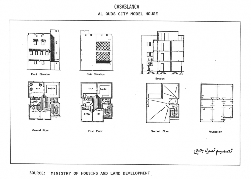
Al Quds City Model House, for Casablanca, showing Front and Side Elevation, Sections, Ground, First and Second Floor, and Foundation building layouts. Original Source: Ministry of Housing and Land Development
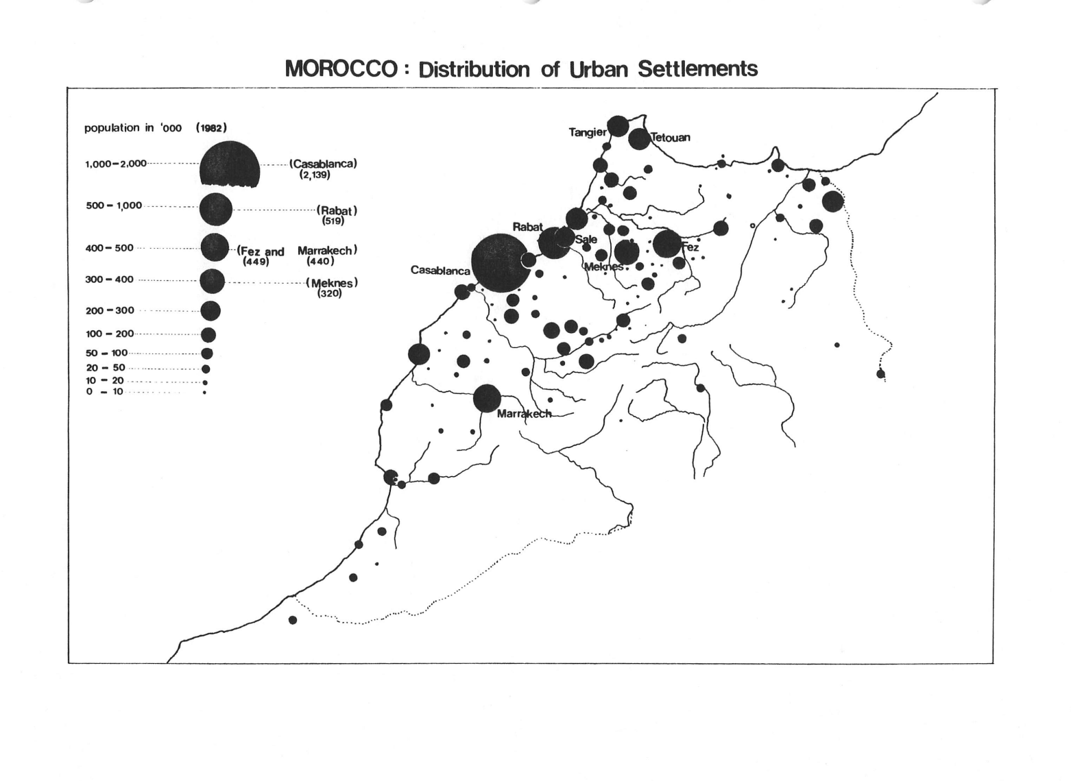
Graphic Map showing the Distribution of Urban Settlements, Morocco, showing data for large settlements in Casablanca, Rabat, Fez, Marrakech, Meknes, Sale, Tangier, and Tetouan.

See related I2UD projects below

Project Year:1989
Project Type:Urban Design Studio
Geographic Regions:Rabat, Morocco
Reports:

1989 Design Studio: “Urban Housing in a Developing Country: Rabat Morocco” (Syllabus)


1989 Design Studio: “Rabat’s Urban Fringe,” Mona Serageldin (Final Report)


1989 Design Studio: “Urban Housing in a Developing Country, Rabat Morocco” (Student Report)


Authors:Mona Serageldin; Samir Abdulac; Fathahah Debbi; Agnes Deboulet; Isabelle Ouetta; Jennifer Wayne; Hung-Song Oh; Randa Tukan;
Sponsors:The Aga Khan Program for Islamic Architecture at Harvard University, and the Massachusetts Institute of Technology
Categories:Design Studios; Education;
  
ID:1989_01_001

Related I2UD Projects


Design Studio 1981: “Housing Design in Islamic Cultures” in Algeria, Bangladesh, Egypt, Iraq, Pakistan, Saudi Arabia and Indonesia, Seminar Curriculum

Design Studio 1984: “The Revitalization of a Traditional Urban Quarter” for the Medieval Darb al Ahmar District, Cairo, Egypt, Seminar Curriculum

Design Studio 1984: “Design, Technology and Logistics for Large Housing Projects,” in Algeria, India, Iraq, Malaysia, Mali and Singapore, Seminar Curriculum

Design Studio 1987: “Arad New Town,” Land-Fill Development Solutions for Arad New Town, Muharraq Island, Bahrain, Seminar Curriculum

Design Studio 1988: “Urban Infrastructure Planning and Programing in Developing Countries,” Chapters 1-7, Seminar Curriculum

Design Studio 1989: “Rabat’s Urban Fringe,”  Urbanization Analysis of Rabat, Morocco – Seminar Curriculum

Design Studio 1990: “The Medina of Tunis,” Urban Regeneration for the Historic Hafsia District, Tunis, Tunisia, Seminar Curriculum

Design Studio 1992: “Cairo and the Medieval City” &”Urban Regeneration in Medieval Cairo,” in Cairo, Egypt, Seminar Curriculum

Design Studio 1993: “Rabat’s Urban Fringe,” Rabat, Morocco, Seminar Curriculum

Design Studio 1994: “A New Urban Center for Adjamé, Abidjan, Ivory Coast,” Seminar Curriculum

Design Studio 1995: “Urban Regeneration and Housing in a Transitional Economy: Lublin, Poland,” Seminar Curriculum

Design Studio 1996: “Strategic Urban Redevelopment in a Transitional Economy in Gdansk, Poland,” Seminar Curriculum

Design Studio 1997: “Strategic Planning and Local Development,” Seminar Curriculum

Design Studio 2003: “Urban Strategies for Economic Recovery: A Revitalization Strategy for New Bedford, Massachusetts,” Seminar Curriculum

Tags

“Computerized Urban Management Methods: PROJECT, AFFORD and PALMS,” Early GIS Computer Software Documentation for Urban Management, 1987-1993

Abstract

Starting in 1987, the Unit developed a pilot suite of three computer software programs for urban management. PROJECT, AFFORD and PALMS (Parcel-Based Land Management System) were data simulation models — designed to assist international public officials in assessing physical factors and financial resources — for housing development and land planning.

Documents below include an AFFORD User manual, a PROJECT User Manual and Description, and a PALMS Progress Report, with maps and slides. Supporting documents include three student reports from the 1988 Design Studio, addressing the use of computerized systems —“Information Systems in the Developing World”“Feasibility of Housing Surveys”“Long Term Human Activities and Ecosystem Responses.”

Timeline: 1989-1993


— 1989 — Mona Serageldin created “AFFORD,” a computer simulation model designed for public planning agencies, for making data assessments on physical standards and financing terms for the production and delivery of housing for limited income groups.

— 1987-1988 — François Vigier created “PROJECT,”
a computer simulation model for programming and phasing large-scale public projects (housing developments, roadways or service corridors, regional rehabilitation). The model allowed the user to easily explore data interactions — among physical, economic and financial variables — to determine the feasibility of projects.

— 1991 — Jonathan Corson-Rikert created “PALMS” (Parcel-Based Land Management System)
as a geographic information system database — and an applications library consisting of commonly encountered urban management decisions for planners.


More context on the Unit’s work with GIS can be found in: “Geographic Information Systems: The Spatial Dimension of Urban Information Management” (Dr. François Vigier, Jonathan Corson-Rikert, Joy Hecht, July 1989). This essay reviewed the emerging field of GIS as of 1989 and the potential applications for urban planning.

Although not included below, Dr. Mona Serageldin and Sherif Lotfi also created a fourth program, “COMPUTE,” in 1993. This analytical model assessed the economic impact of urban land development projects in terms of four key indicators: employment generation, leverage ratio, NPV, and IRR, with a sensitivity analysis.

Project Year:1987-1993
Project Type:GIS Computer Software Program Documentation
Geographic Regions:Global / None Specified
Reports:

AFFORD (User Manual, Mona Serageldin)


PROJECT (Description of Simulation Model)

PROJECT User Manual (François Vigier, 1987)


PALMS (Progress Report, 1988)

PALMS (Maps and Slides)


Student Reports:

Computerized Urban Management Methods:
Feasibility of Housing Surveys” (Student Report)


Computerized Urban Management Methods:
“Information Systems in the Developing World,” (Student Report)


Computerized Urban Management Methods:
“Long Term Human Activities and Ecosystem Responses” (Student Report)


Authors:François Vigier; Mona Serageldin; Peter Rowe; Daniel L. Schodek; Mara Graham; Joy Hecht; Michael W. Binford; Kristina Hill;
Sponsors:Harvard University Graduate School of Design;
Categories:Design Studios; Education; Climate Change; 
  
ID:1988_12_001

Related I2UD Projects

Tags

“The Development and Morphology of Informal Housing,” Research Paper, Published with Aga Khan Award for Architecture Seminar Proceedings, Dr. Mona Serageldin, 1988.

Abstract

Dr. Mona Serageldin authored this research paper in 1988 for the Unit for Housing and Urbanization at Harvard University, published as part of the proceedings of the Aga Khan Award for Architecture Seminar on the “Architecture of Housing” held in Zanzibar, Tanzania in October 1988.

The paper relates the history of housing development processes (1950s-1980s) in the Middle East, North Africa and East African regions, in cities including Tunis (Tunisia,), Damascus (Syria), Cairo (Egypt), Zanzibar (Tanzania), and Sana’a (Yemen). It compares the makeup of circumstances and populations, and describes housing units in each location — covering design and construction, with requirements for designing suitable housing units.


[Excerpt: I. Background: Mona Serageldin]

“The involvement of architects and planners with housing for lower income groups began in the 50’s and 60’s when national governments in the post colonial era embarked on slum eradication programs. Slum dwellers were to be rehoused in public housing estates. To the designers of these first projects, the overriding concern was decent shelter and sanitary conditions and not affordability. That their vision was influenced by prevailing international norms was the natural outcome of their professional training. Their failure to foresee the implications of demographic and economic trends over the next 2 decades invalidated their approach. Their efforts were overwhelmed by population growth, surplus labor, and an influx of rural migrants which could not be checked.

“Throughout the 60’s housing shortages increased and slums proliferated. Frustrated authorities turned to legislative controls, a politically expedient short-term remedy. The longer term impacts were devastating. Stringent controls accelerated the deterioration of the regulated stock, distorted private production, undermined the tax base, hampered residential mobility and warped occupancy patterns.

“The low cost shelter solutions advocated in the 60’s and 70’s produced a variety of expandable core housing prototypes to meet the needs of the urban poor. They were valid models in parts of Africa and Asia where the process happened to coincide with local practices as in Khartoum and Dakar. Elsewhere, the lack of enthusiasm among housing authorities for these approaches stemmed from an accurate perception of their unsuitability as a housing solution for the middle classes, the only client group of political consequence. Leverage and funding from international agencies launched projects in many countries which otherwise might have never experimented with minimal shelter programs. The improvements provided were on a scale too small to be meaningful in relation to the magnitude of the problem or noticeable in the midst of sprawling chaotic cities. By the mid 70’s their demonstration effect had lost its significance.”

“The shock waves in world economics and the resultant movements of labor and capital transformed the character of urban growth throughout the third world. By 1981, 15 million expatriate workers funneled between 25 and 35 billion dollars of foreign exchange back to their home countries. As the bulk of these remittances found their way into real estate, the urbanized area of cities doubled or tripled in extent shaped by uncontrolled housing construction on an unprecedented scale. Functionally defective and aesthetically chaotic environments became the dominant feature of cities, those annual rate of expansion of 4% to 7% outstripped the capacities of municipalities to provide urban services. As a result, their efficiency was impaired and there has been a sharp deterioration in the quality of life.”

See related I2UD projects below

Project Year:1988
Project Type:Research Paper
Geographic Regions:Cairo, Egypt / Damascus, Syria / Tunis, Tunisia / Sana’a, Yemen / Zanzibar, Tanzania
Reports:
The Development and Morphology of Informal Housing: (Mona Serageldin, September 1988)


Authors:Mona Serageldin; Samir Abdulac; Oussama Kabbani; Richard Khan;
Sponsors:Aga Khan Award for Architecture
Categories:Urban Planning
  
ID:1988_09_001

Related I2UD Projects

“World Migration Report,” Background Papers on Displacement, Migration and Resettlement in MENA (Middle East and North Africa), International Organization for Migration, 2014

“Migration, Remittances and Housing in Sub-Saharan Africa,” Study on Senegal, Kenya, and South Africa, with the Swedish International Development Cooperation Agency (SIDA), 2007-2008

“Migration, Remittances and the Empowerment of Women in Central America and the Andean Region,” for PROMESHA, Lund University, 2007-2008

“Habitat III Regional Report for the Arab Region,” for UN-Habitat (ROAS) and United Nations (ESCWA), 2015-2016

“National Urban Strategy for Governorates in Iraq,” Development Strategy for Phase II of the United Nations Development Programme (UNDP) and Iraq Ministry of Planning Local Area Development Programme (LADP II), 2014-2018

“National Urban Policies in Arab States,” Regional Assessment and Case Studies on NUPs in Egypt, Jordan, Morocco, Saudi Arabia and Sudan, 2014

UN-HABITAT Spatial Regional Plan and Assessment for the Kurdistan-Iraq Region Housing Program, 2014

“Inclusive Cities and Access to Land, Housing, and Services in Developing Countries,” Urban Development Series: Knowledge Papers, February 2016, No. 22. World Bank’s Social, Urban, Rural & Resilience Global Practice, 2016

“Basic Services for an Urbanizing World,” Third Global Report on Local Democracy and Decentralization (GOLD III, UCLG). Chapter on “Middle East and West Asia” by Mona Serageldin, I2UD, 2013

World Bank MNA Urban Action Plan – Policy and Strategy Papers: “The Evolving Regional Urban Agenda: Key Challenges and Opportunities,” & “From Spring to Renaissance: Repositioning the Arab Cities,” 2013

“GCC Regional Spatial Strategy – Elements and Considerations,” Urban Development Plan, UN-Habitat Gulf States Regional Office Workshops, 2013

State of Arab Cities 2012 UN-Habitat Report & Conference – “Challenges of Urban Transition: Municipal Management and Urban Development Conference For Sustainability in Arab States,” Kuwait, May 2012

“Comprehensive Plan for Makkah, Madinah and Mashaer,” Urban Development Strategy for Ancient Holy Sites in Saudi Arabia, 2009

Executive Training Course 2006: “Strategic Planning for Sustainable Infrastructure Development,” Workshop Curriculum with Case Studies, Pretoria, South Africa, 2006

“Development Corridors and Urban Development Strategies” and “Slum Improvement Strategies and Social Inclusion,” Presentations by Dr. Mona Serageldin, 11th United Nations Conference on Trade and Development, São Paulo, Brazil, 2004

“Migratory Flows, Poverty and Social Inclusion in Latin America,” Research Report by Dr. Mona Serageldin with Swedish International Development Agency (SIDA), 2004

“Community-Based Urbanization and Favelas Rehabilitation Processes,” Case Study in Academy Editions, “The Architecture of Empowerment: People, Shelter and Livable Cities,” for Fortaleza, Brazil, 1997

“Review of Ongoing USAID Shelter Sector Activities in Morocco,” Report by Dr. Mona Serageldin with ICMA, TSS Inc. for USAID/Morocco Office of Housing and Urban Programs, 1992-1998

Design Studio 1989: “Rabat’s Urban Fringe,” Urbanization Analysis of Rabat, Morocco – Seminar Curriculum

Design Studio 1988: “Urban Infrastructure Planning and Programing in Developing Countries,” Chapters 1-7, Seminar Curriculum

“World Migration Report,” Background Papers on Displacement, Migration and Resettlement in MENA (Middle East and North Africa), International Organization for Migration, 2014

“The Development and Morphology of Informal Housing,” Research Paper, Published with Aga Khan Award for Architecture Seminar Proceedings, Dr. Mona Serageldin, 1988.

Design Studio 1984: “The Revitalization of a Traditional Urban Quarter” for the Medieval Darb al Ahmar District, Cairo, Egypt, Seminar Curriculum

“Best Practices and Local Leadership Programme,” Review of International Urban Development Projects, for the United Nations Centre for Human Settlements (UN-Habitat), 1995

Habitat III Regional Report for the Arab Region: Papers on “Inclusive cities,” “Migration and Refugees in Urban Areas,” and “Land Structure, Process, and Outcome,” for UN-Habitat (ROAS) and United Nations (ESCWA), 2015-2016

World Bank MNA Urban Action Plan – Policy and Strategy Papers: “The Evolving Regional Urban Agenda: Key Challenges and Opportunities,” & “From Spring to Renaissance: Repositioning the Arab Cities,” 2013

“Comprehensive Plan for Makkah, Madinah and Mashaer,” Urban Development Strategy for Ancient Holy Sites in Saudi Arabia, 2009

State of Arab Cities 2012 UN-Habitat Report & Conference – “Challenges of Urban Transition: Municipal Management and Urban Development Conference For Sustainability in Arab States,” Kuwait, May 2012

“Basic Services for an Urbanizing World,” Third Global Report on Local Democracy and Decentralization (GOLD III, UCLG). Chapter on “Middle East and West Asia” by Mona Serageldin, I2UD, 2013

UN-HABITAT Spatial Regional Plan and Assessment for the Kurdistan-Iraq Region Housing Program, 2014

Keynote for City Debates 2015, American University of Beirut: “The Dynamics of Neighborhood Transformation: Long Term Trends and Immediate Responses to Turmoil and Civil Unrest,” Dr. Mona Serageldin

“Inclusive Cities and Access to Land, Housing, and Services in Developing Countries,” Urban Development Series: Knowledge Papers, February 2016, No. 22. World Bank’s Social, Urban, Rural & Resilience Global Practice, 2016

Tags

ITP 1988: “Housing Affordability: Project Appraisal and Program Structure,” with Boston Redevelopment Authority Site Visit, International Training Programs, 1988

Abstract

Documents include case studies for the 1988 International Training Program, addressing the Boston housing economy and detailing site visits with the Boston Redevelopment Authority. Particularly informative is a paper by Dr. Mona Serageldin, “Housing Affordability: Project Appraisal and Program Structure.” This paper details a housing affordability model for urban housing development, and includes data sets used for ITP sessions: tables of basic and urban indicators and global household graphical statistics used for ITP sessions.

See related I2UD projects below

Project Year:1988
Project Type:ITP; Education
Geographic Regions:Boston, Massachusetts, USA
Reports:

ITP 1988: Housing Affordability:
Project Appraisal and Program Structure (Mona Serageldin)


ITP 1988: Housing Affordability:
Affordable Housing in the US Concepts and Selected Projects


ITP 1988: Housing Affordability:
Boston Redevelopment Authority Site Visit


ITP 1988: Housing Affordability:
Boston Redevelopment Authority Supplementary Documentation


Authors:Mona Serageldin;
Sponsors:Unit for Housing and Urbanization of the Harvard University Graduate School of Design
Categories:International Training Program; Education;
  
ID:1988_00_002

Related I2UD Projects

The International Training Programs (ITP) began in 1982, as 2-4 week long summer seminars held by the Unit for Housing and Urbanization (Harvard University) in Cambridge, MA. ITP curriculums were designed to strengthen the decision-making skills of senior professionals in public and private agencies responsible for urban development.

The I2UD Digital Library holds curriculum materials for ITPs from 19881991199419951997 and 1998:

The tradition of ITPs continued after 2000, when CUDS (a re-organization of the Unit) continued training seminars as “International Education Programs” (IEP) from 2000-2004:

Programs included inter-linked modules, lectures, case studies, interactive computer simulation models, site visits to urban projects, discussion groups and networking with professional counterparts from international metropolitan regions. Sessions had a modular format and structured team teaching, taught by a team of senior faculty and guest lecturers. Programs ended with a synthesis presented through a project evaluation exercise. Participants used case projects to examine strategies from the viewpoint of both public and private partners — to assess the feasibility and potential impacts of policies and projects on the community and the city. Presentations by guest speakers representing U.S. and international agencies, NGOs, and community groups were also integrated within the pedagogic framework of each module.

Tags

Design Studio 1988: “Urban Infrastructure Planning and Programing in Developing Countries,” Chapters 1-7, Seminar Curriculum

Abstract

The Design Studio from Spring 1988, “Urban Infrastructure: Planning and Programming in Developing Countries” was developed by Dr. Mona Serageldin, with students and scholars from the Aga Khan Unit for Housing and Urbanization at Harvard University’s Graduate School of Design.

The 1988 Design Studio outlined problems and urban infrastructure programs, illustrated by maps, demographics and case study reports. Curriculum materials give particular attention to support for the urban poor, with case studies on Indonesia, Bahrain, and Zhejiang Province in China. Seven chapters address infrastructure issues in light of rapid urbanization, including unemployment and underemployment in urbanizing countries, and an increased demand for basic needs like water supply and shelter.

A final Design Studio student report, on the Kingdom of Bahrain, features 99 pages of rich spatial, social, commercial and architectural overview of the historic city of Muharraq, Bahrain. Muharraq (Arabic: المحرق or al-Muḥarraq) is Bahrain’s third largest city. See: Organization of World Heritage Cities. Section 5.0 features a paper condensed from Arabic, by Dr. Tareq Wali: “Traditional Urban Fabric and Architecture,” including a substantial list of Tables, Maps, and References. Sections cover the historical evolution of the district: 5.1: The Development of Muharraq; 5.2 Morphology of the Traditional Urban Fabric & The Organization of Space; 5.3 Commercial Element; 5.4 Residential Elements; and Annex: Notes on Building Materials and Architecture.


[Excerpt, Chapter 6, Paper B, The Urban Operational Perspective. “Introduction to the Course Background,” for “Urban Infrastructure, Planning and Programming in Developing Countries, p. 1.1]

“Virtually without exception in the cities and towns of the developing world, the ability to plan, finance and implement urban development programs and infrastructure programs in particular, is in a state of crisis. Severe deficiencies exist and are growing in nearly all sub-sectors. Explosive population growth, partly through immigration from rural areas and in the cases of the largest cities, natural growth, have placed pressures on city authorities for increased services. For instance, the population of the urban areas in developing countries is likely to grow by 1 billion over the next two decades. Simultaneously with growth to date, the state of existing services has universally deteriorated.”

“At the same time the governments in these countries are trying valiantly to cope with what are prime concerns; large and growing unemployment and under employment, and raised expectations by their peoples of access to minimum basic needs in water supply, shelter, etc. These pressures though countrywide, are visibly focused in the urban areas, and thus influence political, administrative, financial, and economic decisions, not always in a coherent or rational manner.”

“Urbanization involves costs to the public sector which amount to large shares of total public spending. Dense human settlement requires levels of servicing – for health reasons, if no other – which are not as essential elsewhere. Rising incomes increase demands for water, electricity, road space, telephones are similar public services. Expectations for urban amenities and appearances are high, and the costs of providing them are also high. Growth of the larger cities often involves diseconomies of scale – longer pumping distances for water and traveling distances for commuters, for example. In some of the largest metropolitan areas, geographical shape and terrain accentuate the costs of growth: Bangkok, Bombay and Mexico City come to mind. Soaring land prices add to the costs of private and public sector development.”

See related I2UD projects below

Project Year:1988
Project Type:Urban Design Studio
Geographic Regions:Indonesia / Muharraq, Bahrain / Zhejiang Province, China
Reports:
1988 Design Studio: Chapter 1 Course Introduction


1988 Design Studio: Chapter 2 Institutional Aspects of Urban Development


1988 Design Studio: Chapter 3 Urban Development and Multi Sectoral Investment Planning


1988 Design Studio: Chapter 4 Selection of Appropriate Infrastructural Standard and Integration of Systems


1988 Design Studio: Chapter 5 Identification Feasibility and Appraisal of Urban Infrastructure (David Cook)


1988 Design Studio: Chapter 6 Paper A Operation and Maintenance


1988 Design Studio: Chapter 6 Paper B The Urban Operational Perspective


1988 Design Studio: Chapter 7 Institutional and Financial Aspects

Authors:Peter Cook; Mona Serageldin; Geeta Pradhan; Mr. Tareq Wali (Senior Architect at the Physical Planning Directorate in the Bahrain Ministry of Housing);
Sponsors:Physical Planning Directorate in the Bahrain Ministry of Housing; Aga Khan Unit for Housing and Urbanization at the Harvard Graduate School of Design;
Categories:Design Studios; Education;
  
ID:1988_00_004

Related I2UD Projects


Design Studio 1981: “Housing Design in Islamic Cultures” in Algeria, Bangladesh, Egypt, Iraq, Pakistan, Saudi Arabia and Indonesia, Seminar Curriculum

Design Studio 1984: “The Revitalization of a Traditional Urban Quarter” for the Medieval Darb al Ahmar District, Cairo, Egypt, Seminar Curriculum

Design Studio 1984: “Design, Technology and Logistics for Large Housing Projects,” in Algeria, India, Iraq, Malaysia, Mali and Singapore, Seminar Curriculum

Design Studio 1987: “Arad New Town,” Land-Fill Development Solutions for Arad New Town, Muharraq Island, Bahrain, Seminar Curriculum

Design Studio 1988: “Urban Infrastructure Planning and Programing in Developing Countries,” Chapters 1-7, Seminar Curriculum

Design Studio 1989: “Rabat’s Urban Fringe,”  Urbanization Analysis of Rabat, Morocco – Seminar Curriculum

Design Studio 1990: “The Medina of Tunis,” Urban Regeneration for the Historic Hafsia District, Tunis, Tunisia, Seminar Curriculum

Design Studio 1992: “Cairo and the Medieval City” &”Urban Regeneration in Medieval Cairo,” in Cairo, Egypt, Seminar Curriculum

Design Studio 1993: “Rabat’s Urban Fringe,” Rabat, Morocco, Seminar Curriculum

Design Studio 1994: “A New Urban Center for Adjamé, Abidjan, Ivory Coast,” Seminar Curriculum

Design Studio 1995: “Urban Regeneration and Housing in a Transitional Economy: Lublin, Poland,” Seminar Curriculum

Design Studio 1996: “Strategic Urban Redevelopment in a Transitional Economy in Gdansk, Poland,” Seminar Curriculum

Design Studio 1997: “Strategic Planning and Local Development,” Seminar Curriculum

Design Studio 2003: “Urban Strategies for Economic Recovery: A Revitalization Strategy for New Bedford, Massachusetts,” Seminar Curriculum

“World Migration Report,” Background Papers on Displacement, Migration and Resettlement in MENA (Middle East and North Africa), International Organization for Migration, 2014

“Migration, Remittances and Housing in Sub-Saharan Africa,” Study on Senegal, Kenya, and South Africa, with the Swedish International Development Cooperation Agency (SIDA), 2007-2008

“Migration, Remittances and the Empowerment of Women in Central America and the Andean Region,” for PROMESHA, Lund University, 2007-2008

“Habitat III Regional Report for the Arab Region,” for UN-Habitat (ROAS) and United Nations (ESCWA), 2015-2016

“National Urban Strategy for Governorates in Iraq,” Development Strategy for Phase II of the United Nations Development Programme (UNDP) and Iraq Ministry of Planning Local Area Development Programme (LADP II), 2014-2018

“National Urban Policies in Arab States,” Regional Assessment and Case Studies on NUPs in Egypt, Jordan, Morocco, Saudi Arabia and Sudan, 2014

UN-HABITAT Spatial Regional Plan and Assessment for the Kurdistan-Iraq Region Housing Program, 2014

“Inclusive Cities and Access to Land, Housing, and Services in Developing Countries,” Urban Development Series: Knowledge Papers, February 2016, No. 22. World Bank’s Social, Urban, Rural & Resilience Global Practice, 2016

“Basic Services for an Urbanizing World,” Third Global Report on Local Democracy and Decentralization (GOLD III, UCLG). Chapter on “Middle East and West Asia” by Mona Serageldin, I2UD, 2013

World Bank MNA Urban Action Plan – Policy and Strategy Papers: “The Evolving Regional Urban Agenda: Key Challenges and Opportunities,” & “From Spring to Renaissance: Repositioning the Arab Cities,” 2013

“GCC Regional Spatial Strategy – Elements and Considerations,” Urban Development Plan, UN-Habitat Gulf States Regional Office Workshops, 2013

State of Arab Cities 2012 UN-Habitat Report & Conference – “Challenges of Urban Transition: Municipal Management and Urban Development Conference For Sustainability in Arab States,” Kuwait, May 2012

“Comprehensive Plan for Makkah, Madinah and Mashaer,” Urban Development Strategy for Ancient Holy Sites in Saudi Arabia, 2009

Executive Training Course 2006: “Strategic Planning for Sustainable Infrastructure Development,” Workshop Curriculum with Case Studies, Pretoria, South Africa, 2006

“Development Corridors and Urban Development Strategies” and “Slum Improvement Strategies and Social Inclusion,” Presentations by Dr. Mona Serageldin, 11th United Nations Conference on Trade and Development, São Paulo, Brazil, 2004

“Migratory Flows, Poverty and Social Inclusion in Latin America,” Research Report by Dr. Mona Serageldin with Swedish International Development Agency (SIDA), 2004

“Community-Based Urbanization and Favelas Rehabilitation Processes,” Case Study in Academy Editions, “The Architecture of Empowerment: People, Shelter and Livable Cities,” for Fortaleza, Brazil, 1997

“Review of Ongoing USAID Shelter Sector Activities in Morocco,” Report by Dr. Mona Serageldin with ICMA, TSS Inc. for USAID/Morocco Office of Housing and Urban Programs, 1992-1998

Design Studio 1989: “Rabat’s Urban Fringe,” Urbanization Analysis of Rabat, Morocco – Seminar Curriculum

Design Studio 1988: “Urban Infrastructure Planning and Programing in Developing Countries,” Chapters 1-7, Seminar Curriculum

Tags

“Urban Strategies for Economic Development: Towards an Agenda for the 90s,” Regional Report and Workshop for Amman, Jordan, 1987

A 1987 report authored by the Unit for Housing and Urbanization and funded by The World Bank, “Urban Strategies for Economic Development: Towards an Agenda for the 90s,” addressed the growth of informal settlements and the lack of adequate housing opportunities for low-income families in Amman, Jordan.

Documents include a Background Report on Amman, Jordan by John Driscoll, a report by Dr. Mona Serageldin from September 1989 titled “Infrastructure Financing and Land Development,” and a workshop summary from October 1989.

Excerpt


[Excerpt: “Infrastructure Financing and Land Development,” Context, Mona Serageldin, pp. 1]

“Within a given economic context, the ability of urban areas to stimulate and drive development is determined by the range and quality of their infrastructure. Throughout the 80’s, intractable budget deficits and increasing debt burdens have led to the curtailment of funding for urban infrastructure in all but one of the OECD countries. In developing nations weak urban institutions inherited from colonial times almost collapsed in the face of mounting needs and dwindling resources. The dynamic private sector could neither muster the capital nor the organizational capabilities needed to operate on the scale required for infrastructure development. Throughout the 70’s and BO’S informal developers maximized profits by externalizing the environmental cost of unplanned urbanization; a cost that the public sector is now forced to absorb. Municipalities struggling to simultaneously service building plots and retrofit uncontrolled settlements have been stretching distribution networks without improved trunk capacity. In many cities, overload well in excess of design capacity risks to collapse whole sectors of the system.”

___


[Excerpt: “Introduction, Background Report on The Urban Development Department” of Amman, John Driscoll, pp. 3, 5.]

“According to World Bank studies, 34% of the urban population lives (ca. 1987) in cramped conditions with four or more persons per room in contrast to the national average of 2.6 persons per room. Development standards prescribing a minimum plot size of 250 to 300 sq. meters with high land prices have made it difficult for the moderate income households to obtain serviced land. Rent control has also distorted the housing market and led to the typical situation of substantial key money requirements, a condition which severely affects new families altering the housing market. Urban population growth, estimated at 5%, coupled with the lack of affordable legal alternatives resulted in the growth of informal settlements on the urban periphery. Ninety percent of housing construction is done by the private sector. Public sector construction is distributed between the UDD, the government owned Jordan Housing Cooperation and smaller housing programs.
….
“In 1980, UDPl represented a major change in government policies regarding the provision of low-income housing and basic services for the urban poor. New development standards made housing more affordable for lower-income groups. The process of comprehensive community upgrading of selected informal settlements and the development of new sites-and-services projects employing cost-recovery principles were a departure from past government practices and policies.”

Project Year:1987
Project Type:Regional Report
Geographic Regions:Amman, Jordan
Reports:

Urban Strategies for Economic Development:
“The Urban Development Department,” Amman, Jordan (September 1989)


Urban Strategies for Economic Development:
“Infrastructure Financing and Urban Development”(September 1989)


Urban Strategies for Economic Development:
“Urban Growth, Economic Opportunity or Hardship” (Summary of the Workshop, October 1989)


Authors:John Driscoll; Mona Serageldin;
Sponsors:The World Bank
Categories:Reconciliation and Development
  
ID:1987_09_001

Related I2UD Projects

“World Migration Report,” Background Papers on Displacement, Migration and Resettlement in MENA (Middle East and North Africa), International Organization for Migration, 2014

“The Development and Morphology of Informal Housing,” Research Paper, Published with Aga Khan Award for Architecture Seminar Proceedings, Dr. Mona Serageldin, 1988.

Design Studio 1984: “The Revitalization of a Traditional Urban Quarter” for the Medieval Darb al Ahmar District, Cairo, Egypt, Seminar Curriculum

“Best Practices and Local Leadership Programme,” Review of International Urban Development Projects, for the United Nations Centre for Human Settlements (UN-Habitat), 1995

Habitat III Regional Report for the Arab Region: Papers on “Inclusive cities,” “Migration and Refugees in Urban Areas,” and “Land Structure, Process, and Outcome,” for UN-Habitat (ROAS) and United Nations (ESCWA), 2015-2016

World Bank MNA Urban Action Plan – Policy and Strategy Papers: “The Evolving Regional Urban Agenda: Key Challenges and Opportunities,” & “From Spring to Renaissance: Repositioning the Arab Cities,” 2013

“Comprehensive Plan for Makkah, Madinah and Mashaer,” Urban Development Strategy for Ancient Holy Sites in Saudi Arabia, 2009

State of Arab Cities 2012 UN-Habitat Report & Conference – “Challenges of Urban Transition: Municipal Management and Urban Development Conference For Sustainability in Arab States,” Kuwait, May 2012

“Basic Services for an Urbanizing World,” Third Global Report on Local Democracy and Decentralization (GOLD III, UCLG). Chapter on “Middle East and West Asia” by Mona Serageldin, I2UD, 2013

UN-HABITAT Spatial Regional Plan and Assessment for the Kurdistan-Iraq Region Housing Program, 2014

Keynote for City Debates 2015, American University of Beirut: “The Dynamics of Neighborhood Transformation: Long Term Trends and Immediate Responses to Turmoil and Civil Unrest,” Dr. Mona Serageldin

“Inclusive Cities and Access to Land, Housing, and Services in Developing Countries,” Urban Development Series: Knowledge Papers, February 2016, No. 22. World Bank’s Social, Urban, Rural & Resilience Global Practice, 2016

Tags

Design Studio 1987: “Arad New Town,” Land-Fill Development Solutions for Arad New Town, Muharraq Island, Bahrain, Seminar Curriculum

Abstract

The Design Studio from Spring 1987, “Arad New Town” of Bahrain, was led by Professors François Vigier and Mona Serageldin under the Department of Urban Planning and Design at Harvard University in 1987. The document is a syllabus for the 1987 topic, a new land development site in the late 1980s in Muharraq Province, Bahrain: Arad New Town.

See related Document Library materials: Design Studio 1988: “Urban Infrastructure Planning and Programing in Developing Countries.”


[Excerpt, Design Studio Syllabus, 1987]:

“The objective of this year’s studio… is to explore solutions that are responsive to the life styles of the future inhabitants of a satellite development in Bahrain, off Muharraq Island, and integrate the modern technology required to create a large-scale project with the cultural traditions of Bahrain and the Gulf area. The policy initiated several years ago to undertake land fills on the coral reefs girding the islands that make up Bahrain offers a rare opportunity to “create” the site as an integral part of the design of the new town. The land fill’s location near the historic town of Muharraq allows the taking into account of the functional, economic, and social interrelationships between the new town and its older neighbor.”

“Arad New Town is to be built on a land-fill (whose geometry has yet to be defined) to be located on a 3.7 square kilometer coral reef and tidal flat extending from the bridge linking old Muharraq and Arad to the village of Halat an Naim
[…] A bridge will be constructed between the site and old Muharraq over the channel that will have to be created to maintain the viability of the ecologically sensitive Dawhat al Muharraq marsh. The new town offers a unique opportunity to simultaneously address ecological, design and implementation issues.”

Project Year:1987
Project Type:Urban Design Studio
Geographic Regions:Arad and Muharraq, Bahrain
Reports:


Authors:François Vigier; Mona Serageldin;
Sponsors:The Aga Khan Program for Islamic Architecture at Harvard University and the Massachusetts Institute of Technology
Categories:Design Studios; Education;
  
ID:1987_00_001

Related I2UD Projects


Design Studio 1981: “Housing Design in Islamic Cultures” in Algeria, Bangladesh, Egypt, Iraq, Pakistan, Saudi Arabia and Indonesia, Seminar Curriculum

Design Studio 1984: “The Revitalization of a Traditional Urban Quarter” for the Medieval Darb al Ahmar District, Cairo, Egypt, Seminar Curriculum

Design Studio 1984: “Design, Technology and Logistics for Large Housing Projects,” in Algeria, India, Iraq, Malaysia, Mali and Singapore, Seminar Curriculum

Design Studio 1987: “Arad New Town,” Land-Fill Development Solutions for Arad New Town, Muharraq Island, Bahrain, Seminar Curriculum

Design Studio 1988: “Urban Infrastructure Planning and Programing in Developing Countries,” Chapters 1-7, Seminar Curriculum

Design Studio 1989: “Rabat’s Urban Fringe,”  Urbanization Analysis of Rabat, Morocco – Seminar Curriculum

Design Studio 1990: “The Medina of Tunis,” Urban Regeneration for the Historic Hafsia District, Tunis, Tunisia, Seminar Curriculum

Design Studio 1992: “Cairo and the Medieval City” &”Urban Regeneration in Medieval Cairo,” in Cairo, Egypt, Seminar Curriculum

Design Studio 1993: “Rabat’s Urban Fringe,” Rabat, Morocco, Seminar Curriculum

Design Studio 1994: “A New Urban Center for Adjamé, Abidjan, Ivory Coast,” Seminar Curriculum

Design Studio 1995: “Urban Regeneration and Housing in a Transitional Economy: Lublin, Poland,” Seminar Curriculum

Design Studio 1996: “Strategic Urban Redevelopment in a Transitional Economy in Gdansk, Poland,” Seminar Curriculum

Design Studio 1997: “Strategic Planning and Local Development,” Seminar Curriculum

Design Studio 2003: “Urban Strategies for Economic Recovery: A Revitalization Strategy for New Bedford, Massachusetts,” Seminar Curriculum

Tags

“Upgrading and Conservation of the Walled City of Lahore,” Regional Report on the Preservation of Historic Lahore, Pakistan, 1988

Abstract

The project “Upgrading and Conservation of the Walled City of Lahore” was implemented by Drs. Rafique H. Keshavjee, Mona Serageldin and François Vigier (of the Unit) in 1987, to address the urban circumstances surrounding the historic Walled City in Lahore, Pakistan.

The report was part of a larger project undertaken between 1978 and 1980, “Lahore Urban Development and Traffic Study” (LUDTS). This study defined issues of urban economics, housing dilapidation, infrastructure development, urban management and finance — in order to develop comprehensive strategies to implement improvements for Lahore, specifically the Walled City.

Documents include a Primary Information paper, Background paper, Preliminary report, Interim report, Progress report and a Project Summary paper. This study format — a robust detailed review and strategic presentation for improvements in historic and low-income urban spaces — was replicated throughout the Unit, CUDS and I2UD’s later work.

See below: Photography Galleries of Lahore, Pakistan: Photography of the Walled City of Lahore — including streetscapes, housing exterior and interiors, and historic architecture in the Walled City. Photography taken for the Unit’s study, later used as case study material, and curated within Dr. Serageldin’s slide collection.


[Excerpt: Overview of the Walled City of Lahore, Primary Information Paper, Page 9-14]

“The Walled City of Lahore, one square mile (2.5 sq. km) in area, is the oldest and most densely populated quarter of the provincial capital of the Punjab. It acquired some of the greatest monuments of Indian Muslim architecture. The palace-fort complex, the vast badshai mosque, as well as the superbly decorated Wazir Khan mosque, with its attached madrasah, bindery stalls and hammam are among the symbols of the heritage of Pakistan. The domestic architecture is also of value, and numerous dwellings, often with rich hierarchies of space, ranging from large homes to palaces of city notables, especially from the Sikh period, dot much of the area….Numerous shrines, mainly tombs of Muslim saints and sages, within and just outside the walls, entire some venerated regularly, some periodically by thousands of Muslims each year, usually in large processions. In short — with its proud history, varied urban texture, 20 protected national monuments, numerous shrines and other estimated 4,000 buildings of cultural value, the Walled City is one of the richest repositories of the nation’s cultural heritage.”

“The Walled City is an integral and vital component of the metropolitan complex. It provides shelter and employment to more than 8% [circa 1988] of Lahore’s population, and contributes about 8% of the revenues collected through property tax, and about 13% of the octroi (trade tax) revenues….”

“…Yet Lahore has one of the highest densities in the world and represents a major concentration of urban poor in the city as a whole. Population densities are the highest in Lahore, ranging around 1,100 persons per hectare…The man-made mound of the old city provides an unstable base for foundations. This, coupled with a falling water-table, frequent seepage from water mains and age, has weakened many of the buildings structurally and even to the point of danger [of collapse]…Of the 22,500 premises, more than one eighth lie vacant where houses have collapsed and not been rebuilt, and more than every twelve is structurally dangerous. Less than 18% of the buildings have been constructed since partition (1947).”

“As a result about one third of the population now live in dilapidated buildings and most dwellings are overcrowded, with nearly seven persons per household….The structures, mainly of burnt brick walls and timber floors and balconies, are densely packed into tiny plots of 42 to 62 sq. m each, rising often 3 or 4 stories. More than half the premises are occupied by single households, about a quarters contain two households each, while the remainder house three or more.”

Recent Trends – Upgrading and Affordability: Owing to the constraints of cost and logistics, increasing attention has been given to in-situ slum upgrading. A prime component of this approach is legalization (through leases) and upgrading of squatter settlements. The Government has also begun to consider the need to reduce land development standards. This is critical to increasing the affordable housing stock, as well as to encouraging conformity of the “informal” building sector with new standards.”

See related I2UD projects below

Project Year:1987
Project Type:Regional Report
Geographic Regions:Lahore, Pakistan
Reports:


Authors:Rafique H. Keshavjee, Ph.D.; Mona Serageldin; François Vigier;
Sponsors:Lahore Urban Development and Traffic Study
Categories:Historic Districts
  
ID:1987_00_003

Related I2UD Projects


Design Studio 1981: “Housing Design in Islamic Cultures” in Algeria, Bangladesh, Egypt, Iraq, Pakistan, Saudi Arabia and Indonesia, Seminar Curriculum

“Economy of Historic Preservation” in Erbil, Kurdistan, Report for Strengthening Urban & Regional Planning (SURP), UN-HABITAT, 2014

“Comprehensive Plan for Makkah, Madinah and Mashaer,” Urban Development Strategy for Ancient Holy Sites in Saudi Arabia, 2009

“Sustainable Development Based on Valorizing the Historic Urban Fabric,” Paper by Dr. Mona Serageldin, 9th World Congress of the Organization of World Heritage Cities in Kazan, Tatarstan, Russia, 2007

“Integrated Area Management Action Plan,” Urban Management Plan for the Ancient Walled City Icheri Sheher, Baku, Azerbaijan, 2006

“Revitalization of Kars Historic Center” & “Strategies for Sustainable Development,” Technical Assistance and Capacity-Building for Kars, Turkey, 2004-2008

“Cooperation and Capacity Building for Promoting Cultural, Natural and Built Heritage in Transylvania,” Technical Assistance Report for Brașov, Sibiu, Sighișoara and Târgu Mureș, Romania, 2004

“Continuity and Change” by Dr. Mona Serageldin, Topic Paper for 48th World Congress, International Federation for Housing and Planning (IFHP), 2004

“Historic Center of Mexico City” Diagnostic Summary, Technical Assistance for Mexico City, Mexico, 2003

“Master Plan for the Revitalization of the Older Urban Fabric,” Preservation in the Old City of Al Qusair, Egypt, 2000

“St. Petersburg Center City Rehabilitation Project,” Urban Planning Network for St. Petersburg, Russia, 2000

“Preserving the Historic Urban Fabric in a Context of Fast Paced Change,” Research Essay by Dr. Mona Serageldin, 1998

“Lublin Local Initiatives Program” & “Lublin Old Town Rehabilitation Project,” Technical Assistance for Urban Upgrading in Lublin, Poland, 1994-2000

“Samarkand, Uzbekistan: Revitalization and Rehabilitation of the Historic District,” Technical Assistance for the City of Samarkand, Uzbekistan, 1994

“Upgrading and Conservation of the Walled City of Lahore,” Regional Report on the Preservation of Historic Lahore, Pakistan, 1988

Tags

Design Studio 1984: “Design, Technology and Logistics for Large Housing Projects,” in Algeria, India, Iraq, Malaysia, Mali and Singapore, Seminar Curriculum

Abstract

The 1984 Design Studio, “Design, Technology and Logistics for Large Housing Projects” was held jointly by Unit for Housing and Urbanization at the Harvard Graduate School of Design and MIT Laboratory of Architecture and Planning from July 23-27, 1984.

Documents include a workshop schedule and summary, a bibliography, a table of contents with list of guest speakers, and background documents on Algeria, India, Iraq, Malaysia, Mali, and Singapore.


[Excerpt: 1984 Design Studio: Workshop Schedule and Summary, p7-8]

Note: See page 7-8 for full Workshop Topic Summaries:

1) Making Large-scale Housing Livable
2) Building Technologies for the Future
3) Alternative Approaches in Low-Cost Housing
4) Implementation and Management Strategies

Project Year:1984
Project Type:Urban Design Studio
Geographic Regions:Algeria / India / Iraq / Malaysia / Mali / Singapore
Reports:
1984 Design Studio: Workshop Schedule and Summary


1984 Design Studio: Bibliography


1984 Design Studio: Table of Contents and Guest Speakers


1984 Design Studio: Algeria (Background Document)


1984 Design Studio: India (Background Document)


1984 Design Studio: Iraq (Background Document)


1984 Design Studio: Malaysia (Background Document)


1984 Design Studio: Mali (Background Document)


1984 Design Studio: Singapore (Background Document)

Authors:François Vigier; Mona Serageldin;
Sponsors:The Aga Khan Program for Islamic Architecture at Harvard University and the Massachusetts Institute of Technology
Categories:Design Studios; Education;
ID:1984_07_001

Related I2UD Projects


Design Studio 1981: “Housing Design in Islamic Cultures” in Algeria, Bangladesh, Egypt, Iraq, Pakistan, Saudi Arabia and Indonesia, Seminar Curriculum

Design Studio 1984: “The Revitalization of a Traditional Urban Quarter” for the Medieval Darb al Ahmar District, Cairo, Egypt, Seminar Curriculum

Design Studio 1984: “Design, Technology and Logistics for Large Housing Projects,” in Algeria, India, Iraq, Malaysia, Mali and Singapore, Seminar Curriculum

Design Studio 1987: “Arad New Town,” Land-Fill Development Solutions for Arad New Town, Muharraq Island, Bahrain, Seminar Curriculum

Design Studio 1988: “Urban Infrastructure Planning and Programing in Developing Countries,” Chapters 1-7, Seminar Curriculum

Design Studio 1989: “Rabat’s Urban Fringe,”  Urbanization Analysis of Rabat, Morocco – Seminar Curriculum

Design Studio 1990: “The Medina of Tunis,” Urban Regeneration for the Historic Hafsia District, Tunis, Tunisia, Seminar Curriculum

Design Studio 1992: “Cairo and the Medieval City” &”Urban Regeneration in Medieval Cairo,” in Cairo, Egypt, Seminar Curriculum

Design Studio 1993: “Rabat’s Urban Fringe,” Rabat, Morocco, Seminar Curriculum

Design Studio 1994: “A New Urban Center for Adjamé, Abidjan, Ivory Coast,” Seminar Curriculum

Design Studio 1995: “Urban Regeneration and Housing in a Transitional Economy: Lublin, Poland,” Seminar Curriculum

Design Studio 1996: “Strategic Urban Redevelopment in a Transitional Economy in Gdansk, Poland,” Seminar Curriculum

Design Studio 1997: “Strategic Planning and Local Development,” Seminar Curriculum

Design Studio 2003: “Urban Strategies for Economic Recovery: A Revitalization Strategy for New Bedford, Massachusetts,” Seminar Curriculum

Tags

Design Studio 1984: “The Revitalization of a Traditional Urban Quarter” for the Medieval Darb al Ahmar District, Cairo, Egypt, Seminar Curriculum

Abstract

The 1984 Design Studio, “The Revitalization of a Traditional Urban Quarter” for Darb al Ahmar, Cairo, addressed the unique dynamics of the historical district of Medieval Darb al Ahmar District in Cairo, Egypt. The Studio was held jointly by Unit for Housing and Urbanization at the Harvard Graduate School of Design and MIT Laboratory of Architecture and Planning in Cambridge, Massachusetts.

Documents include an overview, syllabus, and background paper by Dr. Francois Vigier, with Dr. Mona Sergeldin. This initial research on the significant urban environment in Cairo, Egypt continued to evolve throughout the Unit, CUDS and I2UD’s timeline of study of historical urban spaces. See more on: Historic Districts, Egypt, and Cairo in the I2UD Document Library.


[Excerpt: 1984 Design Studio: Darb Al Ahmar District Medieval Cairo (Overview) 1.0 – Overview, page 80]

“The Darb al Ahmar district is located in the south-eastern portion of the medieval city, between al Azhar University (founded in 972) and Salah ed Din’s Citadel, the seat of government from the 12th century to 1865. It is bounded to the east by remnants of the medieval wall and to the west by Port Said Street, a wide avenue built over the antique canal connecting Cairo to the Red Sea. Its 4.8 km area is equal to roughly one quarter of the medieval city; its 1980 population was estimated at 148,000 or 23% of the medieval city’s population.

The district’s importance lies in its location; for nine hundred years it was the link between the institutions and commercial areas concentrated in the Fatimid City and the seat of government in the citadel. Since the 19th century, its western edge has been the dividing line between the modern, Europeanized city along the Nile and the indigenous urban pattern. Although the rapid expansion of Cairo after World War 1 led to its partial marginalization, this trend has been arrested and there is every indication that intensive development pressures are now at work, threatening the physical and social fabric of the area.”

“The diversity of Darb al Ahmar’s population reflects its long history. In the center, around what has been the main commercial artery since medieval times, a stable resident population working in trade and services is swelled daily by a growing number of students and rural migrants, particularly day laborers. Along the eastern edge, the historically less reputable quarters at the urban periphery are now outflanked by informal settlements spreading into the cemetaries and onto the top of the Makkatam hills. To the west, the boundary created by Port Said Street is no longer the sharp divider between foreign and indigenous population that it was in the colonial era. It is part of the transitional zone between the traditional and modern urban fabrics, leading to the key transport node of Ataba and the government district of Abdine. “


[Excerpt cont’ 1. 1 – Evolution of Darb al Ahmar, page 82]

“The northern half of the district, built as part of the Fatimid town, is bisected by the Qasabat, the main north-south street that runs from Bab al Fut’uh to Bab Zuweyla. Lined with shops serving the residential areas on either side of it, it is still today one of the major shopping streets in the medieval city. In the past, specialty shops were interspersed among the mosques, schools, baths, public fountains, and noble houses that lined the street. Bookstores and stationers were found near Al Azhar, inlaid copper articles were made and sold near the Ghuri mosque while, just off the main street, druggists were manufacturing herbal remedies. Just inside Bab Zuweyla, cooked-food vendors, a fruit market and sweetmeat sellers were to be found in the Suq es Sukkariya; musical instruments were also sold in a nearby market.”

The area outside Bah Zuweyla was first settled as a low density suburb, housing the spill-over population of the Fatimid city. It remained largely undeveloped until the beginning of the 12th century when a governmental edict mandated owners to develop their land or sell it to someone who would, under penalty of confiscation. The first public building built outside the wall, the al Saleh Tala’i mosque, opposite Bab Zuweyla, was completed in 1160. Development occurred along the wall, towards the Nile, and southward, along the two old roads to the old settlement of Fustat, which had continued to strive as a popular district after the official precinct had been moved north to al Qahira. By the end of the 12th century, development trends had been reinforced by the construction of a new fortified wall by Salah ed-Din, which increased the area of the city eight-fold, and by his moving the seat of government from the Fatimid city to a newly built citadel. Densities increased rapidly as commerces and craftsmen thrived along this strategic link between Cairo’s densest districts and the Citadel as two of Darb al Ahmar’s main streets the Tabbana and al Khyamiya provided the shortest route between Bab Zuweyla and Bab el Wazir, the city’s new southernmost gate at the foot of the Citadel. The areas behind these streets were progressively subdivided for residences, ranging in quality from palaces to tenements.”


Index: Darb al Ahmar District, Medieval Cairo, Egypt

1. Overview
– Table 5: Gross Residential Densities (c. 1976)
1.1 Evolution of Darb al Ahmar
1.2 Typology of Monuments
1.3 The Domestic Architecture

2. Transformations.
2.1 Evolution of the Physical Fabric
2.2 Social Change
– Household characteristics.
– Livelihood and income
– Housing conditions

3. Socio-Economic Indicators
3.1 Harah es Sokkariya


Cairo: Statistical Appendix.
Table of Contents:

1. Greater Cairo Housing Characteristics
2. Greater Cairo Employment Structures by Economic Activity
3. Medieval City – Demographic Characteristics
4. Medieval City – Education
5. Medieval City – Marital Status of the Adult Population
6. Medieval City – Household Size and Composition
7. Medieval City – Employment Status
8. Medieval City – Employment Structure by Economic Activity
9. Medieval City – Occupations
10. Medieval City – Commuting Patterns
11. Southern Sector Demographic Characteristics
12. Helwan District – Education
13. Helwan District – Marital Status
14. Helwan District – Household Size and Composition
15. Helwan District – Employment Status
16. Helwan District – Occupation
17. Helwan District – Characteristics of Housing Stock
18. Helwan District – Residential Densities
19. Helwan District – Commuting Patterns


[Excerpt: Darb al Ahmar, Overview: Bibliography, transcribed from hand-written text]

Nadim, Nawal (el Memiri). The Relationships between the sexes in a a Harah of Cairo, Indiana University, Doctoral Dissertation, 1975

Wikan, Unni, “Living conditions among Cairo’s poor – a View from Below, ” Middle East Journal, Vol. 39, No. 1, Winter, 1981(?), pp. 7-26.

Raymond, Andre, Artisans el Commercants au Caire au XVIIe siècle, Damascus; Institut Francais de Damascus, 1974. Tome I. Damas: Presses de l’Ifpo. doi:10.4000/books.ifpo.5950.

Revault, Jacques et Bernard Maury. Palais et maisons du Caire du XIVe au XVIIIe siècle, Le Caire : Institut Français d’Archéologie Orientale du Caire, 1975-79.

Ibrahim, Laila ‘Ali, “Residential Architecture in Mamluk Cairo,” in Mukarnas, Vol. 2, 1984.

Williams, John Allen, “Urbanization and Monument Construction in Mamluk Cairo,” in Makarnas, Vol. 2, 1984


See related I2UD projects below

Project Year:1984
Project Type:Urban Design Studio
Geographic Regions:Darb Al Ahmar, Cairo, Egypt
Reports:

1984 Design Studio: Darb Al Ahmar District Medieval Cairo (Overview)


1984 Design Studio: Darb al Ahmar District Medieval Cairo (Syllabus)


1984 Design Studio: Darb al Ahmar District Medieval Cairo (Vigier)


Authors:François Vigier; Mona Serageldin
Sponsors:The Aga Khan Program for Islamic Architecture at Harvard University and the Massachusetts Institute of Technology
Categories:Design Studios; Education;
  
ID:1984_01_001

Related I2UD Projects


Design Studio 1981: “Housing Design in Islamic Cultures” in Algeria, Bangladesh, Egypt, Iraq, Pakistan, Saudi Arabia and Indonesia, Seminar Curriculum

Design Studio 1984: “The Revitalization of a Traditional Urban Quarter” for the Medieval Darb al Ahmar District, Cairo, Egypt, Seminar Curriculum

Design Studio 1984: “Design, Technology and Logistics for Large Housing Projects,” in Algeria, India, Iraq, Malaysia, Mali and Singapore, Seminar Curriculum

Design Studio 1987: “Arad New Town,” Land-Fill Development Solutions for Arad New Town, Muharraq Island, Bahrain, Seminar Curriculum

Design Studio 1988: “Urban Infrastructure Planning and Programing in Developing Countries,” Chapters 1-7, Seminar Curriculum

Design Studio 1989: “Rabat’s Urban Fringe,”  Urbanization Analysis of Rabat, Morocco – Seminar Curriculum

Design Studio 1990: “The Medina of Tunis,” Urban Regeneration for the Historic Hafsia District, Tunis, Tunisia, Seminar Curriculum

Design Studio 1992: “Cairo and the Medieval City” &”Urban Regeneration in Medieval Cairo,” in Cairo, Egypt, Seminar Curriculum

Design Studio 1993: “Rabat’s Urban Fringe,” Rabat, Morocco, Seminar Curriculum

Design Studio 1994: “A New Urban Center for Adjamé, Abidjan, Ivory Coast,” Seminar Curriculum

Design Studio 1995: “Urban Regeneration and Housing in a Transitional Economy: Lublin, Poland,” Seminar Curriculum

Design Studio 1996: “Strategic Urban Redevelopment in a Transitional Economy in Gdansk, Poland,” Seminar Curriculum

Design Studio 1997: “Strategic Planning and Local Development,” Seminar Curriculum

Design Studio 2003: “Urban Strategies for Economic Recovery: A Revitalization Strategy for New Bedford, Massachusetts,” Seminar Curriculum


Design Studio 1981: “Housing Design in Islamic Cultures” in Algeria, Bangladesh, Egypt, Iraq, Pakistan, Saudi Arabia and Indonesia, Seminar Curriculum

“Economy of Historic Preservation” in Erbil, Kurdistan, Report for Strengthening Urban & Regional Planning (SURP), UN-HABITAT, 2014

“Comprehensive Plan for Makkah, Madinah and Mashaer,” Urban Development Strategy for Ancient Holy Sites in Saudi Arabia, 2009

“Sustainable Development Based on Valorizing the Historic Urban Fabric,” Paper by Dr. Mona Serageldin, 9th World Congress of the Organization of World Heritage Cities in Kazan, Tatarstan, Russia, 2007

“Integrated Area Management Action Plan,” Urban Management Plan for the Ancient Walled City Icheri Sheher, Baku, Azerbaijan, 2006

“Revitalization of Kars Historic Center” & “Strategies for Sustainable Development,” Technical Assistance and Capacity-Building for Kars, Turkey, 2004-2008

“Cooperation and Capacity Building for Promoting Cultural, Natural and Built Heritage in Transylvania,” Technical Assistance Report for Brașov, Sibiu, Sighișoara and Târgu Mureș, Romania, 2004

“Continuity and Change” by Dr. Mona Serageldin, Topic Paper for 48th World Congress, International Federation for Housing and Planning (IFHP), 2004

“Historic Center of Mexico City” Diagnostic Summary, Technical Assistance for Mexico City, Mexico, 2003

“Master Plan for the Revitalization of the Older Urban Fabric,” Preservation in the Old City of Al Qusair, Egypt, 2000

“St. Petersburg Center City Rehabilitation Project,” Urban Planning Network for St. Petersburg, Russia, 2000

“Preserving the Historic Urban Fabric in a Context of Fast Paced Change,” Research Essay by Dr. Mona Serageldin, 1998

“Lublin Local Initiatives Program” & “Lublin Old Town Rehabilitation Project,” Technical Assistance for Urban Upgrading in Lublin, Poland, 1994-2000

“Samarkand, Uzbekistan: Revitalization and Rehabilitation of the Historic District,” Technical Assistance for the City of Samarkand, Uzbekistan, 1994

“Upgrading and Conservation of the Walled City of Lahore,” Regional Report on the Preservation of Historic Lahore, Pakistan, 1988

“World Migration Report,” Background Papers on Displacement, Migration and Resettlement in MENA (Middle East and North Africa), International Organization for Migration, 2014

“The Development and Morphology of Informal Housing,” Research Paper, Published with Aga Khan Award for Architecture Seminar Proceedings, Dr. Mona Serageldin, 1988.

Design Studio 1984: “The Revitalization of a Traditional Urban Quarter” for the Medieval Darb al Ahmar District, Cairo, Egypt, Seminar Curriculum

“Best Practices and Local Leadership Programme,” Review of International Urban Development Projects, for the United Nations Centre for Human Settlements (UN-Habitat), 1995

Habitat III Regional Report for the Arab Region: Papers on “Inclusive cities,” “Migration and Refugees in Urban Areas,” and “Land Structure, Process, and Outcome,” for UN-Habitat (ROAS) and United Nations (ESCWA), 2015-2016

World Bank MNA Urban Action Plan – Policy and Strategy Papers: “The Evolving Regional Urban Agenda: Key Challenges and Opportunities,” & “From Spring to Renaissance: Repositioning the Arab Cities,” 2013

“Comprehensive Plan for Makkah, Madinah and Mashaer,” Urban Development Strategy for Ancient Holy Sites in Saudi Arabia, 2009

State of Arab Cities 2012 UN-Habitat Report & Conference – “Challenges of Urban Transition: Municipal Management and Urban Development Conference For Sustainability in Arab States,” Kuwait, May 2012

“Basic Services for an Urbanizing World,” Third Global Report on Local Democracy and Decentralization (GOLD III, UCLG). Chapter on “Middle East and West Asia” by Mona Serageldin, I2UD, 2013

UN-HABITAT Spatial Regional Plan and Assessment for the Kurdistan-Iraq Region Housing Program, 2014

Keynote for City Debates 2015, American University of Beirut: “The Dynamics of Neighborhood Transformation: Long Term Trends and Immediate Responses to Turmoil and Civil Unrest,” Dr. Mona Serageldin

“Inclusive Cities and Access to Land, Housing, and Services in Developing Countries,” Urban Development Series: Knowledge Papers, February 2016, No. 22. World Bank’s Social, Urban, Rural & Resilience Global Practice, 2016

Tags

International Training Programs (ITP) 1982-2000: Survey of Modules for International Training Program Seminars

Abstract

Documents below represent a survey of ITP materials between 1982-2000, including a list of modules, and a history summary, ITP Archives Brochures from 1993-2000, with case studies on the Boston Charlestown Navy Yard, New Market in Roxbury, and London’s Docklands on the Isle of Dogs. See A History of ITP and IEP Seminars below for more information on ITP work.

Modules below represent a range of topics, some repeated for later years of International Training Programs:

  • Strategic Planning and the Financing of Urban Development;
  • Financing Infrastructure and Urban Services;
  • Urban Environmental Improvements Through Community Empowerment;
  • Accessing Resources for Community Development;
  • Economic and Financial Assessment of Urban Projects;
  • Financing Affordable Housing and Infrastructure Planning.

See related I2UD projects below

Project Year:1982-2000
Project Type:ITP; Education
Geographic Regions:Charlestown Navy Yard and Newmarket, Boston, USA / Isle of Dogs and Surry Docks, London, UK / Santa Cruz Island, Ecuador
Reports:

ITP: (List of Modules)


ITP: (History Summary)


Brochures, 1993-2000:

ITP: Archives Brochure (1993)


ITP: Archives Brochure (1996)


ITP: Archives Summary (1996)


ITP: Archives Brochure (1998)


ITP: Archives Brochure (1999)


ITP: Archives Brochure (2000)


Case Studies:

ITP: Charlestown Navy Yard (Case Study)


ITP: New Market Roxbury Boston (Case Study)


ITP: Innstad New Town (Fictional Case Study)


ITP: The London Docklands (Case Study)


ITP: The Isle of Dogs London Docklands Redevelopment (Case Study)


Authors:François Vigier; Victor Karen; Barry Shaw;
Sponsors:Unit for Housing and Urbanization of the Harvard University Graduate School of Design
Categories:International Training Program; Education;
  
ID:1982_00_001

Related I2UD Projects

The International Training Programs (ITP) began in 1982, as 2-4 week long summer seminars held by the Unit for Housing and Urbanization (Harvard University) in Cambridge, MA. ITP curriculums were designed to strengthen the decision-making skills of senior professionals in public and private agencies responsible for urban development.

The I2UD Digital Library holds curriculum materials for ITPs from 19881991199419951997 and 1998:

The tradition of ITPs continued after 2000, when CUDS (a re-organization of the Unit) continued training seminars as “International Education Programs” (IEP) from 2000-2004:

Programs included inter-linked modules, lectures, case studies, interactive computer simulation models, site visits to urban projects, discussion groups and networking with professional counterparts from international metropolitan regions. Sessions had a modular format and structured team teaching, taught by a team of senior faculty and guest lecturers. Programs ended with a synthesis presented through a project evaluation exercise. Participants used case projects to examine strategies from the viewpoint of both public and private partners — to assess the feasibility and potential impacts of policies and projects on the community and the city. Presentations by guest speakers representing U.S. and international agencies, NGOs, and community groups were also integrated within the pedagogic framework of each module.

Tags

Design Studio 1981: “Housing Design in Islamic Cultures” in Algeria, Bangladesh, Egypt, Iraq, Pakistan, Saudi Arabia and Indonesia, Seminar Curriculum

Abstract

The 1981 Design Studio, “Housing Design in Islamic Cultures,” was held jointly by Unit for Housing and Urbanization at the Harvard Graduate School of Design and MIT Laboratory of Architecture and Planning in August 1981.

Documents include a syllabus, an essay on “Determinants of Housing Design” by Professor Vigier, an Essay on the “Role of the Public Sector” by Ismail Serageldin, and a bibliography on “Housing and Housing Design in the Muslim World” by Aga Khan/MIT librarian Richard Dewey.

Supporting materials include background papers on M’Sila, Algeria, Dhaka, Bangladesh, El Mounira Imbaba, Egypt, Iraq National Context, Karachi, Pakistan, Yanbu Industrial City, Saudi Arabia, and Indonesia.

See related I2UD projects below

Project Year:1981
Project Type:Urban Design Studio
Geographic Regions:Dhaka, Bangladesh / Karachi, Pakistan / Yanbu Industrial City, Saudi Arabia / Iraq / Egypt / M’Sila, Algeria / Indonesia
Reports:
1981 Design Studio: Housing Design in Islamic Cultures (Syllabus)


1981 Design Studio: Determinants of Housing Design (Introduction)


1981 Design Studio: Architecture and Contemporary Arab Style of Life (Msila, Algeria)


1981 Design Studio: Core Housing Scheme at Mohammedpur (Dacca, Bangladesh)


1981 Design Studio: El Mounira Imbaba Informal Settlement (Greater Cairo, Egypt)


1981 Design Studio: Housing and House Design in the Muslim World (Bibliography, Richard Dewey)


1981 Design Studio: Lines Area Resettlement Project (Karachi, Pakistan)


1981 Design Studio: Planning and Financing Urban Development The Role of Public Sector (Ismail Serageldin)


1981 Design Studio: Residential Community (Yanbu Industrial City, Saudi Arabia)


1981 Design Studio: Iraq Bab Al Sheikh Project (Summary Paper)


National Urban Context Background Papers:


1981 Design Studio: Iraq Baghdad Urban Context (Background Paper)


1981 Design Studio: Iraq National Context (Background Paper)


1981 Design Studio: Pakistan (Background Paper)


1981 Design Studio: Saudi Arabia (Background Paper)


1981 Design Studio: Algeria (Background Paper)


1981 Design Studio: Bangladesh (Background Paper)


1981 Design Studio: Egypt (Background Paper)


1981 Design Studio: Indonesia (Background Paper)


Authors:Mona Serageldin; François Vigier; Ismail Serageldin; Assia Khellaf; Altaf Mulla; Aminul Haq Khan; Nadia Al Hasani; Akhtar Badshah; Isam Alimam; Javed Sultan; Mohamed El-Sioufi; Richard H. Dewey;
Sponsors:The Aga Khan Program for Islamic Architecture at Harvard University; and the Massachusetts Institute of Technology Laboratory of Architecture and Planning
Categories:Design Studios; Education;
  
ID:1981_08_001

Related I2UD Projects


Design Studio 1981: “Housing Design in Islamic Cultures” in Algeria, Bangladesh, Egypt, Iraq, Pakistan, Saudi Arabia and Indonesia, Seminar Curriculum

Design Studio 1984: “The Revitalization of a Traditional Urban Quarter” for the Medieval Darb al Ahmar District, Cairo, Egypt, Seminar Curriculum

Design Studio 1984: “Design, Technology and Logistics for Large Housing Projects,” in Algeria, India, Iraq, Malaysia, Mali and Singapore, Seminar Curriculum

Design Studio 1987: “Arad New Town,” Land-Fill Development Solutions for Arad New Town, Muharraq Island, Bahrain, Seminar Curriculum

Design Studio 1988: “Urban Infrastructure Planning and Programing in Developing Countries,” Chapters 1-7, Seminar Curriculum

Design Studio 1989: “Rabat’s Urban Fringe,”  Urbanization Analysis of Rabat, Morocco – Seminar Curriculum

Design Studio 1990: “The Medina of Tunis,” Urban Regeneration for the Historic Hafsia District, Tunis, Tunisia, Seminar Curriculum

Design Studio 1992: “Cairo and the Medieval City” &”Urban Regeneration in Medieval Cairo,” in Cairo, Egypt, Seminar Curriculum

Design Studio 1993: “Rabat’s Urban Fringe,” Rabat, Morocco, Seminar Curriculum

Design Studio 1994: “A New Urban Center for Adjamé, Abidjan, Ivory Coast,” Seminar Curriculum

Design Studio 1995: “Urban Regeneration and Housing in a Transitional Economy: Lublin, Poland,” Seminar Curriculum

Design Studio 1996: “Strategic Urban Redevelopment in a Transitional Economy in Gdansk, Poland,” Seminar Curriculum

Design Studio 1997: “Strategic Planning and Local Development,” Seminar Curriculum

Design Studio 2003: “Urban Strategies for Economic Recovery: A Revitalization Strategy for New Bedford, Massachusetts,” Seminar Curriculum


Design Studio 1981: “Housing Design in Islamic Cultures” in Algeria, Bangladesh, Egypt, Iraq, Pakistan, Saudi Arabia and Indonesia, Seminar Curriculum

“Economy of Historic Preservation” in Erbil, Kurdistan, Report for Strengthening Urban & Regional Planning (SURP), UN-HABITAT, 2014

“Comprehensive Plan for Makkah, Madinah and Mashaer,” Urban Development Strategy for Ancient Holy Sites in Saudi Arabia, 2009

“Sustainable Development Based on Valorizing the Historic Urban Fabric,” Paper by Dr. Mona Serageldin, 9th World Congress of the Organization of World Heritage Cities in Kazan, Tatarstan, Russia, 2007

“Integrated Area Management Action Plan,” Urban Management Plan for the Ancient Walled City Icheri Sheher, Baku, Azerbaijan, 2006

“Revitalization of Kars Historic Center” & “Strategies for Sustainable Development,” Technical Assistance and Capacity-Building for Kars, Turkey, 2004-2008

“Cooperation and Capacity Building for Promoting Cultural, Natural and Built Heritage in Transylvania,” Technical Assistance Report for Brașov, Sibiu, Sighișoara and Târgu Mureș, Romania, 2004

“Continuity and Change” by Dr. Mona Serageldin, Topic Paper for 48th World Congress, International Federation for Housing and Planning (IFHP), 2004

“Historic Center of Mexico City” Diagnostic Summary, Technical Assistance for Mexico City, Mexico, 2003

“Master Plan for the Revitalization of the Older Urban Fabric,” Preservation in the Old City of Al Qusair, Egypt, 2000

“St. Petersburg Center City Rehabilitation Project,” Urban Planning Network for St. Petersburg, Russia, 2000

“Preserving the Historic Urban Fabric in a Context of Fast Paced Change,” Research Essay by Dr. Mona Serageldin, 1998

“Lublin Local Initiatives Program” & “Lublin Old Town Rehabilitation Project,” Technical Assistance for Urban Upgrading in Lublin, Poland, 1994-2000

“Samarkand, Uzbekistan: Revitalization and Rehabilitation of the Historic District,” Technical Assistance for the City of Samarkand, Uzbekistan, 1994

“Upgrading and Conservation of the Walled City of Lahore,” Regional Report on the Preservation of Historic Lahore, Pakistan, 1988

Tags