Abstract
Beginning in July 2015, Mona Serageldin, Daniel Tsai, and Barbara Summers from I2UD prepared presentation materials for the 7th Africities Conference, held on November 29, 2015, in Johannesburg, South Africa.
Conference presentations include an Inception Report, and workshop documents and agendas from July 2015, in French and English. Case studies from July and November 2015 discuss Cairo and Khartoum. A final presentation, “Looking Back, Looking Forward: Johannesburg,” was given by Phillip Harrison (SA Research Chair for Spatial Analysis & City Planning of Johannesburg).
Excerpt
[Excerpt: Index and List of Figures for “Cairo Case Study for the Africities Conference Report,” I2UD, 2015]
Related I2UD Projects
Related by: City or Community Case Studies
- “Planning for Climate Adaptation Program” for Four Dominican Republic Municipalities (Project ID: 2015_10_002)
- “National Urban Policies in Arab States,” Regional Assessment and Case Studies on NUPs in Egypt, Jordan, Morocco, Saudi Arabia, and Sudan (Project ID: 2014_08_001)
- “Arusha Urbanization Strategy and Urban Development Plan,” Development Strategy for Arusha Municipality, Tanzania (Project ID: 2012_01_001)
- ICLRD: Urban Reconciliation Case Studies for Public Housing Estates in Ireland and Northern Ireland, with Study Profile on the Basel Metropolitan Area (Project ID: 2010_05_001)
- Executive Training Course 2006: “Strategic Planning for Sustainable Infrastructure Development,” Workshop Curriculum with Case Studies, Pretoria, South Africa (Project ID: 2006_11_001)
- IEP 2003: “Infrastructure and Partnerships for Local Economic Development” in Pretoria and Bloemfontein, South Africa (Project ID: 2003_08_001)
- IEP 2002: “Strategic Planning for Local Development & Urban Revitalization,” Program Overview (Project ID: 2002_01_001)
- “Indicators of Performance for Local Development,” Case Study on the LITMUS Programme by the Borough of Southwark, London, 2001 (Project ID: 2001_09_003)
- Workshops on “Strategic Planning and Management of Municipal Infrastructure Programs,” from Review of Grant-Funded MIPs in South Africa (Project ID: 1999_05_002)
- “Housing Microfinance Initiatives,” Case Study for USAID Microenterprise Best Practices Initiative (Project ID: 1999_00_001)
- ITP 1998: “The Role of Public/Private Partnerships in Urban Improvements,” with Case Studies on Kreuzberg, Berlin (Germany), GIS Mapping on Cape Cod (US), and the Maarouf Quarter of Cairo (Egypt) (Project ID: 1998_07_001)
- “City of Szczecin Capital Improvement Program,” Case Studies for Technical Assistance Program, Szczecin, Poland (Project ID: 1996_06_002)
- ITP 1994: “Revitalization in Older Urban Spaces,” Upham’s Corner, Dorchester, Boston, South Boston, and New Haven (US); Montpellier (France); and Cork (Ireland) with Case Studies (Project ID: 1994_07_001)
- “Introduction to Local Finances,” Teaching Monographs and Case Studies on Finance Management, 1994-1999 (Project ID: 1994_07_002)
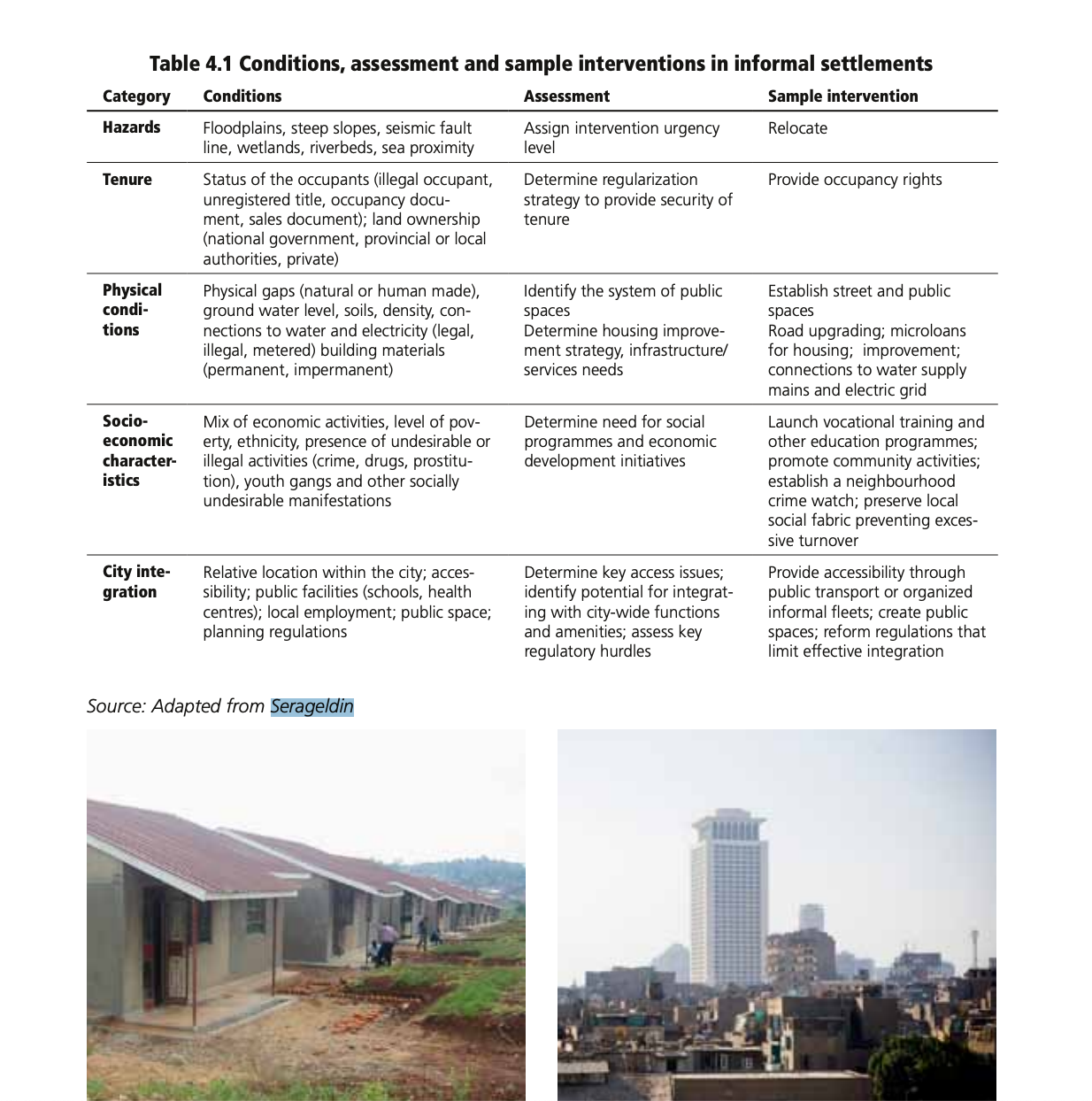
- “Regularizing the Informal Land Development Process,” International Case Studies for the USAID Office of Housing and Urban Programs, Mona Serageldin (Project ID: 1990_10_001)
Related I2UD Photograph Galleries