
Abstract
The Design Studio from 1989, “Rabat’s Urban Fringe,” presented the urban evolution of Rabat, Morocco from 1987 through the early 1990s. Hosted by the Aga Khan Program for Islamic Architecture at Harvard University and the Massachusetts Institute of Technology, the seminar covered Rabat’s urban development experience as a case study for Seminar attendees. Professors Francois Vigier and Mona Serageldin led the sessions, research, and discussions.
Seminar materials focused on analyzing methods to accelerate the release of land for urban development in Rabat, and to discourage imbalanced city growth patterns. The studio covered the application of standards that balance climate requirements, socio-cultural needs, and affordability, the creation of cost-efficient designs to support the economic life of projects, and the use of politically-feasible mechanisms to improve cost recovery and affordability. This topic was repeated in Urban Design Studio curricula from 1989 to 1993.
Documents include a seminar syllabus and overview report; a full report, “Rabat’s Urban Fringe,” with text by Mona Serageldin, supported by the Seminar’s research team; and a final student report on urban planning in Rabat.
Excerpt
[Excerpt: Syllabus, Overview, Spring 1989, Mr. Vigier, Ms. Serageldin, pp. 1-2.]
“Urban Housing in Rabat, Morocco,” An Overview:
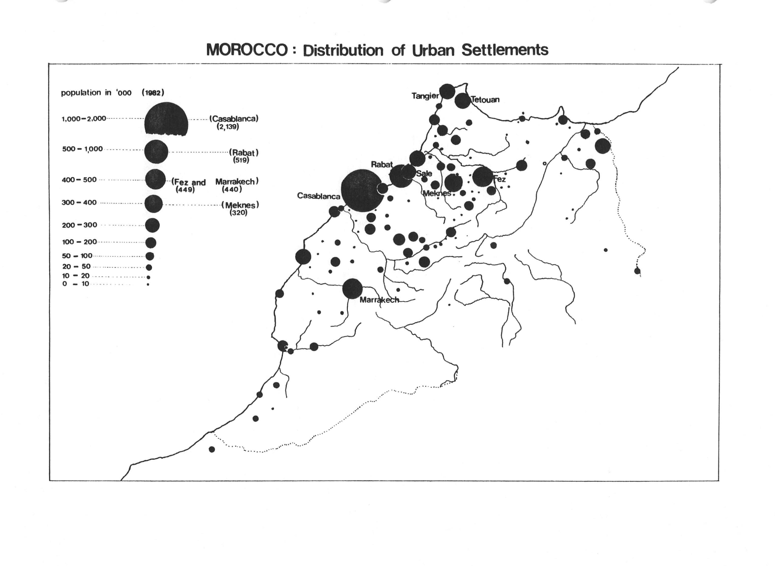
“Urban areas of Third World countries are growing rapidly as a result of a high rate of natural increase of the population and of migration from rural areas. In older areas, usually highly accessible to a broad range of job opportunities, continued population pressures is causing a densification of the housing stock which is deteriorating rapidly from lack of maintenance and subdivision into smaller units. Their infrastructure systems are utilized well beyond their design capacity, creating an increasingly unsanitary environment and threatening the structural soundness of buildings. More recently, governments have had to cope with a dynamic private sector whose activities have proved difficult to control.”
“At present [ca. 1989], the urban fringe is developing rapidly as squatter and informal settlements, ranging in quality from little more than shacks to sound housing for moderate income households striving to improve their standard of living, are built illegally. Currently accounting for sixty to eighty percent of housing starts, these fringe developments present an unprecedented challenge to planners and public officials concerned with preventing urban sprawl and maintaining control over the dynamics of growth in order to provide efficiently the necessary infrastructure and services.”
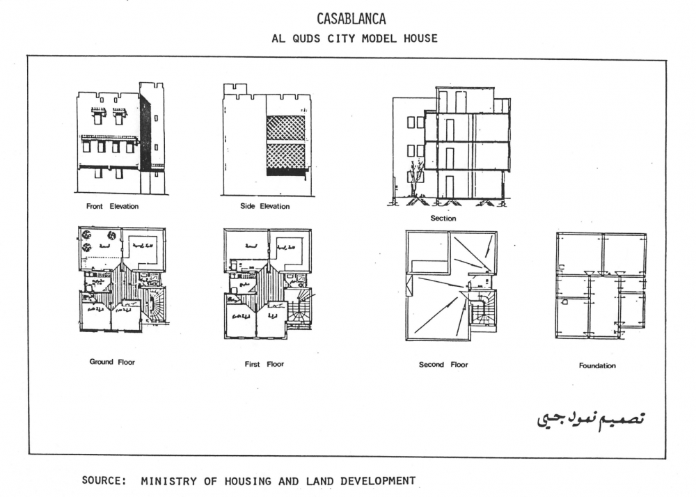
“Planning and Design Issues. High rates of urban growth necessitate forceful public interventions to direct the development of the urban fringe and improve the functional efficiency of older districts. Located in both older areas and on the urban fringe, large-scale projects are being undertaken to upgrade the infrastructure, extend the capacity of transportation systems, provide public amenities, and build mixed-use developments.”
“Yet, the prevalence of poverty has overtaxed the ability of governments to provide adequate public services or enforce even minimum sanitary standards of housing for the majority of urban households. Government housing policies have sought to reconcile three potentially conflicting objectives:
— “A commitment to improve the standard of life of a population largely unable to afford safe and sanitary housing on the open market.”
— “The desire to utilize planning and design standards reflecting international norms as the means to provide an acceptable level of amenities in both older areas and the developing urban fringe.”
— “The necessity to keep public subsidies at a manageable level in the face of the rising demand generated by the rapid growth of the urban population.”
See related I2UD projects below
| Project Year: | 1989 |
| Project Type: | Urban Design Studio |
| Geographic Regions: | Rabat, Morocco |
| Reports: | |
| Authors: | Mona Serageldin; Samir Abdulac; Fathahah Debbi; Agnes Deboulet; Isabelle Ouetta; Jennifer Wayne; Hung-Song Oh; Randa Tukan |
| Sponsors: | Aga Khan Program for Islamic Architecture |
| Categories: | Design Studios; Education |
| ID: | 1989_01_001 |
Related I2UD Projects
Related by: Design Studio Seminars (1981-2003)
- Design Studio 1981: “Housing Design in Islamic Cultures” in Algeria, Bangladesh, Egypt, Iraq, Pakistan, Saudi Arabia and Indonesia, Seminar Curriculum (Project ID: 1981_08_001)
- Design Studio 1984: “The Revitalization of a Traditional Urban Quarter” for the Medieval Darb al Ahmar District, Cairo, Egypt, Seminar Curriculum (Project ID: 1984_01_001)
- Design Studio 1984: “Design, Technology and Logistics for Large Housing Projects,” in Algeria, India, Iraq, Malaysia, Mali, and Singapore, Seminar Curriculum (Project ID: 1984_07_001)
- Design Studio 1987: “Arad New Town,” Land-Fill Development Solutions for Arad New Town, Muharraq Island, Bahrain, Seminar Curriculum (Project ID: 1987_00_001)
- Design Studio 1988: “Urban Infrastructure Planning and Programing in Developing Countries,” Chapters 1-7, Seminar Curriculum (Project ID: 1988_00_004)
- Design Studio 1989: “Rabat’s Urban Fringe,” Urbanization Analysis of Rabat, Morocco, Seminar Curriculum (Project ID: 1989_01_001)
- Design Studio 1990: “The Medina of Tunis,” Urban Regeneration for the Historic Hafsia District, Tunis, Tunisia, Seminar Curriculum (Project ID: 1990_00_002)
- Design Studio 1992: “Cairo and the Medieval City” &”Urban Regeneration in Medieval Cairo,” in Cairo, Egypt, Seminar Curriculum (Project ID: 1992_00_002)
- Design Studio 1993: “Rabat’s Urban Fringe,” Rabat, Morocco, Seminar Curriculum (Project ID: 1993_00_001)
- Design Studio 1994: “A New Urban Center for Adjamé, Abidjan, Ivory Coast,” Seminar Curriculum (Project ID: 1994_01_001)
- Design Studio 1995: “Urban Regeneration and Housing in a Transitional Economy: Lublin, Poland,” Seminar Curriculum (Project ID: 1995_00_001)
- Design Studio 1996: “Strategic Urban Redevelopment in a Transitional Economy in Gdansk, Poland,” Seminar Curriculum (Project ID: 1996_01_001)
- Design Studio 1997: “Strategic Planning and Local Development,” Seminar Curriculum (Project ID: 1997_01_001)
- Design Studio 2003: “Urban Strategies for Economic Recovery: A Revitalization Strategy for New Bedford, Massachusetts,” Seminar Curriculum (Project ID: 2003_09_001)
Related by: Housing
- ITP 1988: “Housing Affordability: Project Appraisal and Program Structure,” with Boston Redevelopment Authority Site Visit (Project ID: 1988_00_002)
- Design Studio 1989: “Rabat’s Urban Fringe,” Urbanization Analysis of Rabat, Morocco, Seminar Curriculum (Project ID: 1989_01_001)
- “Environmental Health Factors in Housing,” Design Study for the Rapid Urbanization of Low-Income Settlements in Urban-Fringe Districts (Project ID: 1989_07_001)
- “Second Urban Project,” Urban Development Study Proposals for Conakry, Republic of Guinea (Project ID: 1990_01_002)
- “Strategy for Technical Assistance and Training: Housing and Land Management in Poland,” Technical Assistance Report by Mona Serageldin (Project ID: 1992_00_001)
- “Review of Ongoing USAID Shelter Sector Activities in Morocco,” Report by Mona Serageldin for USAID/Morocco Office of Housing and Urban Programs, 1992-1998 (Project ID: 1992_00_004)
- Design Studio 1993: “Rabat’s Urban Fringe,” Rabat, Morocco, Seminar Curriculum (Project ID: 1993_00_001)
- “The Use of Land and Infrastructure in the Self-Improvement Strategies of Urban Lower Income Families,” Paper by Mona Serageldin, UN-Habitat Fourteenth Commission Report (Project ID: 1993_05_001)
- Design Studio 1994: “A New Urban Center for Adjame, Abidjan, Ivory Coast,” Seminar Curriculum (Project ID: 1994_01_001)
- Design Studio 1995: “Urban Regeneration and Housing in a Transitional Economy: Lublin, Poland,” Seminar Curriculum (Project ID: 1995_00_001)
- “Community-Based Urbanization and Favelas Rehabilitation Processes,” Case Study for Fortaleza, Brazil (Project ID: 1995_00_006)
- “Community Based Credit for Housing, Infrastructure, and Microenterprises,” Micro-Finance Housing Shortage Study for Quito, Ecuador (Project ID: 1995_03_003)
- Design Studio 1996: “Strategic Urban Redevelopment in a Transitional Economy in Gdansk, Poland,” Seminar Curriculum (Project ID: 1996_01_001)
- ITP 1997: “South Boston Metropolitan Area Community Housing,” Case Studies from Boston, Massachusetts (Project ID: 1997_00_002)
- City of Boston’s “Neighborhood Partnership Initiative” & “Main Street Program,” Urban Revitalization for Roslindale and West Roxbury, Boston, United States (Project ID: 1997_05_001)
- “Housing Microfinance Initiatives,” Case Study for USAID Microenterprise Best Practices Initiative, 1999-2000 (Project ID: 1999_00_001)
- “Migration, Remittances and Housing in Sub-Saharan Africa,” Study on Senegal, Kenya, and South Africa with SIDA, 2007-2008 (Project ID: 2007_07_001)
- Executive Education Program 2007: “Strategic Planning for Sustainable Human Settlements,” Pretoria, South Africa (Project ID: 2007_11_001)
- “Improvement Strategies for Affordable Housing in Yerevan, Armenia,” Development Strategy (Project ID: 2008_01_001)
- “Township Development Strategy for Emfuleni Municipality,” Technical Assistance to Sedibeng, Gauteng, South Africa (Project ID: 2009_03_001)
- ICLRD: Urban Reconciliation Case Studies for Public Housing Estates in Ireland and Northern Ireland, with Study Profile on the Basel Metropolitan Area, 2010-2012 (Project ID: 2010_05_001)
- UN-Habitat Spatial Regional Plan and Assessment for the Kurdistan-Iraq Region Housing Program (Project ID: 2014_06_001)
Related by: Islamic Architecture
- Design Studio 1981: “Housing Design in Islamic Cultures” in Algeria, Bangladesh, Egypt, Iraq, Pakistan, Saudi Arabia, and Indonesia, Seminar Curriculum (Project ID: 1981_08_001)
- Design Studio 1984: “The Revitalization of a Traditional Urban Quarter” for the Medieval Darb al Ahmar District, Cairo, Egypt, Seminar Curriculum (Project ID: 1984_01_001)
- “Upgrading and Conservation of the Walled City of Lahore,” Regional Report on the Preservation of Historic Lahore, Pakistan (Project ID: 1987_00_003)
- “The Development and Morphology of Informal Housing,” Research Paper, Aga Khan Award for Architecture Seminar Proceedings, Mona Serageldin (Project ID: 1988_09_001)
- Design Studio 1989: “Rabat’s Urban Fringe,” Urbanization Analysis of Rabat, Morocco, Seminar Curriculum (Project ID: 1989_01_001)
- Design Studio 1990: “The Medina of Tunis,” Urban Regeneration for the Historic Hafsia District, Tunis, Tunisia, Seminar Curriculum (Project ID: 1990_00_002)
- Design Studio 1992: “Cairo and the Medieval City” and ”Urban Regeneration in Medieval Cairo,” in Cairo, Egypt, Seminar Curriculum (Project ID: 1992_00_002)
- Design Studio 1993: “Rabat’s Urban Fringe,” Rabat, Morocco, Seminar Curriculum (Project ID: 1993_00_001)
- “Monitoring Processes of Change in Historic Centers: A Case Study of Fes, Morocco,” Case Study Paper for UNESCO World Heritage Center and ICCROM (Project ID: 2002_11_001)
- “Comprehensive Plan for Makkah, Madinah and Mashaer,” Urban Development Strategy for Ancient Holy Sites in Saudi Arabia (Project ID: 2009_04_001)
Related I2UD Photograph Galleries