Abstract
In 2008, the International Centre for Local and Regional Development (ICLRD) published the Atlas of the Island of Ireland in cooperation with the All-Island Research Observatory (AIRO), to illustrate similarities and contrasts between Northern Ireland (part of the United Kingdom) and the Republic of Ireland. While both jurisdictions on the Island of Ireland were undergoing rapid change, a common understanding of the major demographic, economic, and social trends was lacking and unavailable from the respective censuses.
The 2008 Atlas allowed readers to visualize the major social, economic, and demographic trends and interactions across the island of Ireland. Its publication helped to initiate evidence-informed dialogues among policy- and decision-makers on the functional space, where cooperation could bring mutual benefits, rather than the political space alone.
In 2015, ICLRD published a new print and digital edition of the Atlas. With European Union and cross-border funding support, ICLRD and AIRO continued to develop compatible data between the respective censuses.
Finally, a series of training programs and workshops were held to train government staff and community development practitioners on how to access and use all-island interactive data and mapping tools made available on the AIRO website. These ‘data days’ were introduced based on exchange visits, facilitated by I2UD, among senior staff of AIRO, the Boston Foundation, and the Boston Metropolitan Area Planning Council.
Documents include the Atlas of the Ireland of Ireland from 2015 and two versions from 2008–the full document as well as the same document divided into separate files by chapter.
See related I2UD projects below
| Project Year: | 2008-2015 |
| Project Type: | ICLRD Project |
| Geographic Regions: | Ireland / Northern Ireland |
| Reports: |
2008 Atlas by Chapter: |
| Authors: | Justin Gleeson; James Walsh; Chris Van Egeraat; Gavin Daly; Rob Kitchin; Mark Boyle; Andrew McClelland; Ronan Foley; Trutz Haaze; Johnathan Pratschke |
| Sponsors: | ICLRD; All-Island Research Observatory (AIRO); Department of Environment, Local Government and Heritage (Government of Ireland); CroSPlaN, European Union INTERREG IIIA and IVA |
| ID: | 2008_00_001 |
Related I2UD Projects
I2UD Digital Library Study Guide: Post-Conflict Reconciliation
I2UD Digital Library Study Guide: The Role of Urban Planning and Management in Post-Crisis Reconciliation and Recovery, October 2025
- “Strategy for Technical Assistance and Training: Housing and Land Management in Poland,” Technical Assistance Report by Mona Serageldin (Project ID: 1992_00_001)
- “Framework for Land Management and Urban Development in a Market Economy,” Mission Report with Case Studies Annexes, for Tirana, Albania (Project ID: 1994_00_001)
- “Lublin Local Initiatives Program” & “Lublin Old Town Rehabilitation Project,” Technical Assistance for Urban Upgrading in Lublin, Poland, 1994-2000 (Project ID: 1994_08_001)
- Design Studio 1995: “Urban Regeneration and Housing in a Transitional Economy: Lublin, Poland,” Seminar Curriculum (Project ID: 1995_00_001)
- Design Studio 1996: “Strategic Urban Redevelopment in a Transitional Economy in Gdansk, Poland,” Seminar Curriculum (Project ID: 1996_01_001)
- “City of Szczecin Capital Improvement Program,” Case Studies for Technical Assistance Program, Szczecin, Poland (Project ID: 1996_06_002)
- “Review of the South African Government’s Grant-Funded Municipal Infrastructure Programs,” Technical Reports, 1998-1999 (Project ID: 1998_08_001)
- “Preserving the Historic Urban Fabric in a Context of Fast Paced Change,” Cultural Heritage Essay by Mona Serageldin (Project ID: 1998_11_001)
- “Szczecin Local Initiative Program,” Urban Improvement Intervention Strategy, USAID Regional Housing and Urban Development Office, Szczecin, Poland (Project ID: 1999_05_001)
- Workshops on “Strategic Planning and Management of Municipal Infrastructure Programs,” Review of Grant-Funded MIPs in South Africa (Project ID: 1999_05_002)
- “Reconnaissance Report: Local Economic Development,” Regional Planning Survey for Bucharest, Romania (Project ID: 2000_02_001)
- IEP October 2000: “Seminar on Strategic Planning for Urban Revitalization and Local Development” in Pretoria, South Africa (Project ID: 2000_10_001)
- IEP May 2001: “Infrastructure Planning and Partnerships for Local Economic Development,” Eastern Cape, South Africa (Project ID: 2001_05_001)
- IEP August 2001: “Infrastructure Planning and Partnerships for Local Economic Development,” Pretoria, South Africa (Project ID: 2001_08_003)
- “Svishtov: A Community-Based Investment Program for Municipal Development,” Technical Assistance for Capital Investment Strategy in Svishtov, Bulgaria (Project ID: 2002_03_001)
- ICLRD: Annual Conference Reports on Urban Planning for the Island of Ireland, 2004-2017 (Project ID: 2004_05_001)
- “Cooperation and Capacity Building for Promoting Cultural, Natural and Built Heritage in Transylvania,” Technical Assistance Report, Romania (Project ID: 2004_09_001)
- “Continuity and Change” by Mona Serageldin, Topic Paper for 48th World Congress, International Federation for Housing and Planning (IFHP) (Project ID: 2004_09_002)
- “Romania Local Governance Bridge Program – Metropolitan Planning and Cooperation in Romania,” USAID-ROMANIA Report (Project ID: 2005_07_001)
- ICLRD: Spatial Strategies for Peace and Reconciliation on the Island of Ireland – Collected Reports by the International Centre for Local & Regional Development, 2006-2013 (Project ID: 2006_06_001)
- “The Atlas of the Island of Ireland: Mapping Social and Economic Change,” Publication by ICLRD, 2008 and 2015 (Project ID: 2008_00_001)
- “Shaping and Managing Cross-Border Development,” ICLRD Executive Training Program Materials for Irish Border Cities, 2010-2014 (Project ID: 2009_00_004)
- ICLRD: Urban Reconciliation Case Studies for Public Housing Estates in Ireland and Northern Ireland, 2010-2012 (Project ID: 2010_05_001)
- “Borderlands: The Journal of Spatial Planning in Ireland,” ICLRD Publication, 2011, 2013 (Project ID: 2011_00_001)
- “Technical Assistance to Lesedi Local Municipality,” Design Framework for South Africa’s Neighborhood Development Partnership Grant, Gauteng Province, South Africa (Project ID: 2011_08_001)
- ICLRD Briefing Papers 2012-2016: “Implementation of River Basin Management Plans,” “Fit for the Future: Organisational Change and Development,” and “Applying the Functional Territories Concept: Planning Beyond Borders” (Project ID: 2012_00_001)
- “The Unplanned Areas Upgrading and Employment Enhancing Programme in Egypt,” Needs Assessment and Activity Design Study for Informal Settlements, 2011-2016 (Project ID: 2012_10_004)
- World Bank MNA Urban Action Plan, Policy and Strategy Papers: “The Evolving Regional Urban Agenda: Key Challenges and Opportunities” and “From Spring to Renaissance: Repositioning the Arab Cities” (Project ID: 2013_01_001)
- UN-Habitat Spatial Regional Plan and Assessment for the Kurdistan-Iraq Region Housing Program (Project ID: 2014_06_001)
- “Economy of Historic Preservation” in Erbil, Kurdistan: Strengthening Urban & Regional Planning (SURP), UN-Habitat (Project ID: 2014_06_002)
- “World Migration Report,” Background Papers on Displacement, Migration, and Resettlement in MENA, International Organization for Migration (Project ID: 2014_09_001)
- “National Urban Strategy for Governorates in Iraq,” Development Strategy for Phase II of the United Nations Development Programme (UNDP) and Iraq Ministry of Planning Local Area Development Programme (LADP II), 2014-2018 (Project ID: 2014_11_001)
- Keynote for City Debates 2015, American University of Beirut: “The Dynamics of Neighborhood Transformation: Long Term Trends and Immediate Responses to Turmoil and Civil Unrest,” Mona Serageldin (Project ID: 2015_03_001)
- “Habitat III Regional Report for the Arab Region,” for UN-Habitat (ROAS) and United Nations (ESCWA), 2015-2016 (Project ID: 2015_10_003)
- “Integrated Development Plan in Support of the Socio-Economic Integration of Former Burundian Refugees in Tanzania,” Technical Assistance (Project ID: 2015_11_001)
- “Local Aspects of Humanitarian Response to Transit Migrants and Refugees in Croatia” (Project ID: 2016_01_001)
Related by: Directed by ICLRD
- ICLRD: Annual Conference Reports on Urban Planning for the Island of Ireland, 2004-2017 (Project ID: 2004_05_001)
- ICLRD: Spatial Strategies for Peace and Reconciliation on the Island of Ireland – Collected Research Reports (Project ID: 2006_06_001)
- “The Atlas of the Island of Ireland: Mapping Social and Economic Change,” ICLRD Publication (Project ID: 2008_00_001)
- “Shaping and Managing Cross-Border Development,” ICLRD Executive Training Program Materials, for Irish Border Cities (Project ID: 2009_00_004)
- ICLRD: Urban Reconciliation Case Studies for Public Housing Estates in Ireland and Northern Ireland (Project ID: 2010_05_001)
- “Borderlands: The Journal of Spatial Planning in Ireland,” ICLRD Publication (Project ID: 2011_00_001)
- ICLRD Briefing Papers 2012-2016: “Implementation of River Basin Management Plans” and “Applying the Functional Territories Concept: Planning Beyond Borders” (Project ID: 2012_00_001)
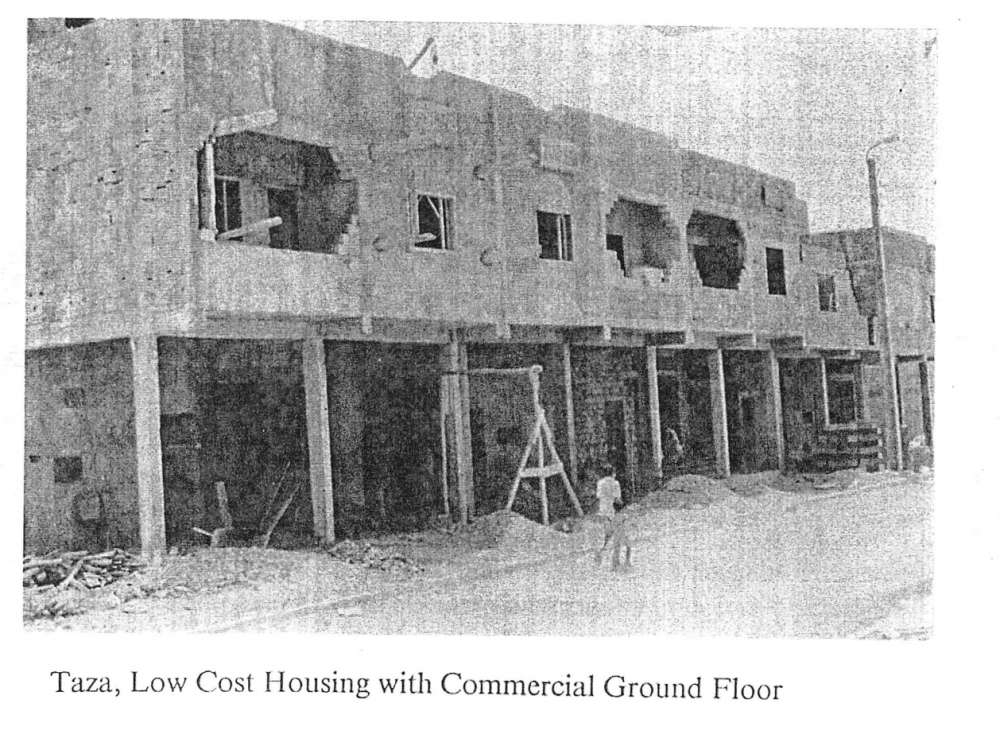 Taza, Low Cost Housing with Commercial Ground Floor